
Coon Run (East Branch Oil Creek tributary) facts for kids
Quick facts for kids Coon Run |
|
|---|---|


|
|
| Other name(s) | Tributary to East Branch Oil Creek |
| Country | United States |
| State | Pennsylvania |
| County | Crawford |
| Township | Rome Sparta |
| Physical characteristics | |
| Main source | divide between Coon Run and Brannon Run about 2 miles southeast of Glynden, Pennsylvania 1,650 ft (500 m) 41°45′32″N 079°41′04″W / 41.75889°N 79.68444°W |
| River mouth | East Branch Oil Creek Glynden, Pennsylvania 1,322 ft (403 m) 41°46′41″N 079°43′13″W / 41.77806°N 79.72028°W |
| Length | 2.35 mi (3.78 km) |
| Basin features | |
| Progression | northwest |
| River system | Allegheny River (Oil Creek) |
| Basin size | 1.24 square miles (3.2 km2) |
| Tributaries |
|
| Bridges | Koon Road, Fairview Road, Whitney Road, Fish Flats Road, Glynden Road, Grade Road |
Coon Run is a small stream, also known as a 'run,' located in Crawford County, Pennsylvania. It flows for about 2.35 miles (3.78 kilometers) and eventually joins a larger stream called East Branch Oil Creek.
The Journey of Coon Run
Coon Run begins in a hilly area, about 2 miles (3.2 kilometers) southeast of a place called Glynden, Pennsylvania. It starts near a dividing line for another stream called Brannon Run.
From there, Coon Run flows mainly towards the northwest. It travels through a flat, glacier-formed area known as the Erie Drift Plain. Finally, it reaches and joins East Branch Oil Creek right in Glynden.
What is Coon Run's Watershed Like?
A watershed is the area of land where all the water drains into a specific stream or river. Coon Run's watershed covers about 1.24 square miles (3.21 square kilometers).
- This area gets about 45.5 inches (115.6 cm) of rain and snow each year.
- About 57% of the land in the watershed is covered by forests. This helps keep the water clean and provides homes for wildlife.
Images for kids
-
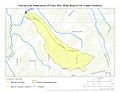
This map shows the path of Coon Run and the area it drains in Crawford County, Pennsylvania.
.jpg)
