
Britton Run (East Branch Oil Creek tributary) facts for kids
Quick facts for kids Britton Run |
|
|---|---|


|
|
| Other name(s) | Tributary to East Branch Oil Creek |
| Country | United States |
| State | Pennsylvania |
| County | Crawford |
| Township | Rome Sparta |
| Physical characteristics | |
| Main source | divide between Britton Run and Lilley Run pond about 1.5 miles west-southwest of Concord Corners, Pennsylvania 1,658 ft (505 m) 41°50′56″N 079°44′26″W / 41.84889°N 79.74056°W |
| River mouth | East Branch Oil Creek about 0.5 miles west of Glynden, Pennsylvania 1,311 ft (400 m) 41°46′20″N 079°43′44″W / 41.77222°N 79.72889°W |
| Length | 6.9 mi (11.1 km) |
| Basin features | |
| Progression | southwest then southeast |
| River system | Allegheny River (Oil Creek) |
| Basin size | 9.3 square miles (24 km2) |
| Tributaries |
|
| Bridges | Chelton Hill Road, Canadohta Lake Road, Britton Run Road (x2), PA 77, Firth Road |
Britton Run is a small stream, about 6.9 miles (11.1 kilometers) long, located in Crawford County, Pennsylvania. It flows into a larger stream called East Branch Oil Creek.
Where Britton Run Flows
Britton Run starts from a pond near Concord Corners, Pennsylvania. It flows first towards the southwest, then turns to the southeast. This journey takes it through an area called the Erie Drift Plain. Finally, Britton Run joins East Branch Oil Creek, close to a place called Glynden, Pennsylvania.
About the Britton Run Watershed
A watershed is an area of land where all the water drains into a single stream or river. The Britton Run watershed covers about 9.3 square miles (24 square kilometers). This area gets about 46.2 inches (117 centimeters) of rain or snow each year. About 40% of the land in this watershed is covered by forests.
Images for kids
-
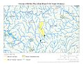
This map shows the path of Britton Run.
-
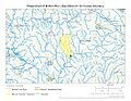
This map shows the entire area that drains into Britton Run.
.jpg)
.jpg)
