Springboro, Pennsylvania facts for kids
Quick facts for kids
Springboro, Pennsylvania
|
|
|---|---|
|
Borough
|
|

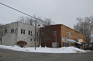
Commercial district at the crossroads
|
|

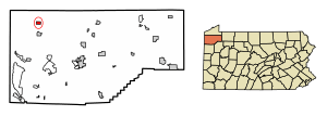
Location of Springboro in Crawford County, Pennsylvania.
|
|
| Country | United States |
| State | Pennsylvania |
| County | Crawford |
| Founded | 1800 |
| Area | |
| • Total | 0.83 sq mi (2.15 km2) |
| • Land | 0.83 sq mi (2.15 km2) |
| • Water | 0.00 sq mi (0.00 km2) |
| Elevation
(middle of borough)
|
940 ft (290 m) |
| Highest elevation
(northeast corner of borough)
|
1,100 ft (300 m) |
| Lowest elevation
(Conneaut Creek)
|
890 ft (270 m) |
| Population
(2020)
|
|
| • Total | 376 |
| • Estimate
(2022)
|
371 |
| • Density | 538.00/sq mi (207.75/km2) |
| Time zone | UTC-4 (EST) |
| • Summer (DST) | UTC-5 (EDT) |
| Area code(s) | 814 |
Springboro is a small town, also called a borough, in Crawford County, Pennsylvania, United States. It is located about 35 miles southwest of the city of Erie. In 2020, about 376 people lived in Springboro. This was a decrease from 477 people counted in 2010.
History of Springboro
Springboro became an official borough in the spring of 1866. However, the area was known as Springboro much earlier, starting in 1840. The year 2015 marked its 175th anniversary!
Geography and Location
Springboro is found in the northwestern part of Crawford County. It is surrounded by a different area called Spring Township.
Pennsylvania Route 18 is a main road that goes right through the middle of Springboro. If you travel north on this road for about 6 miles, you will reach Albion. If you go south for about 3 miles, you will get to Conneautville.
The borough covers a total area of about 2.15 square kilometers (0.83 square miles), and all of it is land. Conneaut Creek flows north through the western side of Springboro. This creek eventually empties into Lake Erie.
Population and People
The number of people living in Springboro has changed over the years. Here's how the population has grown and shrunk:
| Historical population | |||
|---|---|---|---|
| Census | Pop. | %± | |
| 1870 | 323 | — | |
| 1880 | 379 | 17.3% | |
| 1890 | 490 | 29.3% | |
| 1900 | 603 | 23.1% | |
| 1910 | 614 | 1.8% | |
| 1920 | 542 | −11.7% | |
| 1930 | 487 | −10.1% | |
| 1940 | 570 | 17.0% | |
| 1950 | 611 | 7.2% | |
| 1960 | 583 | −4.6% | |
| 1970 | 584 | 0.2% | |
| 1980 | 557 | −4.6% | |
| 1990 | 471 | −15.4% | |
| 2000 | 491 | 4.2% | |
| 2010 | 477 | −2.9% | |
| 2020 | 376 | −21.2% | |
| 2022 (est.) | 371 | −22.2% | |
| Sources: | |||
In 2000, there were 491 people living in Springboro. These people lived in 183 households, and 133 of these were families. The population density was about 577.5 people per square mile. There were 208 housing units in the borough.
Most of the people in Springboro were White (96.33%). A smaller number were African American (3.46%) or Native American (0.20%).
About 32.8% of the households had children under 18 living with them. More than half (51.4%) were married couples. About 12.6% of households had a female head with no husband present.
The average household had 2.68 people, and the average family had 3.17 people.
The population was spread out by age:
- 27.3% were under 18 years old.
- 9.2% were between 18 and 24.
- 30.1% were between 25 and 44.
- 20.2% were between 45 and 64.
- 13.2% were 65 years or older.
The average age of people in Springboro was 34 years. For every 100 females, there were about 99.6 males.
The median income for a household in Springboro was $36,875. For a family, the median income was $40,694. The average income per person in the borough was $14,258. About 9.7% of the total population lived below the poverty line. This included 11.0% of those under 18 and 5.6% of those 65 or older.
Religion
About 1 mile north of Springboro, you can find the Monastery of the Nativity of the Most Holy Theotokos. This monastery belongs to the Serbian Orthodox Church.
See also
 In Spanish: Springboro (Pensilvania) para niños
 | Selma Burke |
 | Pauline Powell Burns |
 | Frederick J. Brown |
 | Robert Blackburn |


