
Sruwaddacon Bay facts for kids
Quick facts for kids Sruwaddacon Bay |
|
|---|---|

Sruwaddacon estuary
|
|

Sruwaddacon Bay
Location in Ireland
|
|
| Location | County Mayo |
| Coordinates | 54°16′N 9°47′W / 54.267°N 9.783°W |
| Ocean/sea sources | Atlantic |
| Basin countries | Ireland |
Sruwaddacon Bay is a special place in County Mayo, Ireland. It's an estuary, which means it's where a river meets the sea. Its Irish name, Sruth Fada Con, means "stream of the long hound." This name fits because of its long, winding shape.
Sruwaddacon Bay is very important for nature. It's a protected area for many animals and plants. It also has a rich history. The bay connects to the Atlantic Ocean through Broadhaven Bay.
The estuary is about 8.4 square kilometers in size. It has a main channel fed by the Glenamoy and Muingnabo rivers. Another channel flows near the village of Rossport. Both channels join together, and the water moves quickly as it reaches the wider bay near the sea.
Contents
Nature and Wildlife
Sruwaddacon Bay is home to many sea creatures. When the tide is low, some parts are very shallow. Large areas of land become visible, which is called the intertidal zone. This area is mostly natural, with very little pollution from people.
The outer part of the bay has sandy beaches and sand dunes. The middle part has rocks and stones. The upper part has a mix of sand and mud. Most of the bay does not have many plants growing in the water.
The water in the middle and lower parts of the bay is quite salty, like the ocean. But closer to the Glenamoy and Muingnabo rivers, the water becomes much fresher.
Important Animals and Plants
Sruwaddacon Bay and Broadhaven Bay are vital places for wildlife. They are important breeding grounds for salmon, whales, and dolphins. These bays also support local fishing and fun activities like boating.
You can find many small creatures living in the mudflats, like worms and clams. There are also special salt marshes, especially in the lower parts of the bay. Plants like sea thrift, sea arrowgrass, and sea plantain grow here.
The bay is also a great spot for birds. Many types of terns and black-headed gulls breed here. You might also see red-breasted mergansers and sand martins.
Discoveries from the Past
In 2008, a team of archaeologists explored Sruwaddacon Bay. They took samples from under the bay. In one sample, they found hazelnut shells about 10.7 meters deep! These shells are being studied to find out how old they are. This discovery helps us learn about what the area was like long ago.
Corrib Gas Project
The Corrib gas project involves bringing natural gas from offshore to land. To do this, a company called Shell planned to build a tunnel under Sruwaddacon Bay. This tunnel would carry a pipeline for the gas. The project has been a big topic of discussion in the local community for many years.
Images for kids
-
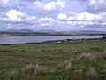
Upper reaches of estuary at Aughoose
-
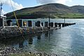
Rossport Pier
-
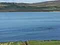
Dolphins in Sruwaddacon Estuary
-
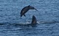
Bottlenose dolphins play in the Bay


