St. Michael, Pennsylvania facts for kids
St. Michael is a small community in Cambria County, Pennsylvania, in the United States. It is known as a census-designated place, which means it's an area identified by the U.S. Census Bureau for statistical purposes. In 2010, about 408 people lived there.
St. Michael has its own ZIP code, which is 15951. It used to be part of a larger census area called St. Michael-Sidman. But for the 2010 census, St. Michael became its own separate place.
Quick facts for kids
St. Michael, Pennsylvania
|
|
|---|---|

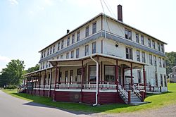
Clubhouse for the former South Fork Fishing and Hunting Club
|
|
| Country | United States |
| State | Pennsylvania |
| County | Cambria |
| Township | Adams |
| Area | |
| • Total | 1.05 sq mi (2.72 km2) |
| • Land | 1.04 sq mi (2.70 km2) |
| • Water | 0.01 sq mi (0.03 km2) |
| Elevation | 1,601 ft (488 m) |
| Population
(2010)
|
|
| • Total | 408 |
| • Density | 392/sq mi (151.4/km2) |
| Time zone | UTC-5 (Eastern (EST)) |
| • Summer (DST) | UTC-4 (EDT) |
| ZIP code |
15951
|
| FIPS code | 42-67352 |
| GNIS feature ID | 1186465 |
Where is St. Michael?
St. Michael is located in the southeastern part of Cambria County. It sits in a valley near the South Fork of the Little Conemaugh River.
The community is less than a mile southeast of U.S. Route 219. This is a four-lane highway. It can take you about 12 miles north to Ebensburg, which is the county seat. You can also travel about 11 miles southwest to Johnstown using Pennsylvania Route 56.
The community of Sidman is also nearby. It is about one mile southeast of St. Michael. Sidman is also in the valley of the South Fork river.
See also
 In Spanish: St. Michael (Pensilvania) para niños
 | Tommie Smith |
 | Simone Manuel |
 | Shani Davis |
 | Simone Biles |
 | Alice Coachman |


