St Austell River facts for kids
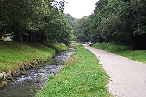
The St Austell River is a river in south Cornwall, England. It is about 12 kilometers (7.5 miles) long. In the Cornish language, its name is Dowr an Wynyk, which means "the little white river." People also know it as the River Vinnick or The White River. Sometimes, it was even called the "red river" because of all the tin mining that happened upstream.
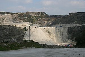
This river helps drain the middle part of the St Austell Moorland. This moorland is a large area of granite rock in Cornwall. The highest natural point there is Hensbarrow Beacon, which is 312 meters (1,024 feet) tall. However, today there are even taller piles of waste from china clay mining.
The name "White River" became popular because waste water from china clay quarries and factories used to flow into it. This made the river look white. The name "White River" was even used for a big shopping area in St Austell called White River Place.
Contents
Where Does the St Austell River Flow?
The St Austell River has two main parts, called tributaries, that join together.
The First Branch of the River
One part of the river starts near Hensbarrow Beacon. It flows southeast past the Gunheath china clay pit. Then, it turns south and goes through places like Carthew, Ruddlemoor, and Trethowel. This area is called the Trenance Valley. Many old mills and blowing houses (places where tin was processed) used the river here.
The Trenance Valley is a deep, V-shaped valley cut into the granite rock. Several smaller streams and springs join the river in this section. These include water from places like Gunheath, Lansalson, and Bojea. At the end of the Trenance Valley, the river flows under the Cornish Main Line railway and enters the town of St Austell.
The Second Branch of the River
The other main part of the river starts inside a huge china clay pit called Littlejohn's/Dorothy. This area used to be a long, shallow valley called Longstone Moor. It collected water from the high moorland.
This part of the river flows south under a very large pile of mining waste. It comes out from a tunnel at the start of the Gover Valley. From there, it winds south until it reaches another railway bridge for the Cornish Main Line. After that, it turns east and flows for about one kilometer into St Austell, where it meets the first branch of the river.
The River's Journey to the Sea
After leaving St Austell, the river flows south through the Pentewan Valley. This valley is about 5 kilometers (3 miles) long. The river continues until it reaches the village of Pentewan. Here, the St Austell River flows into the English Channel at Pentewan beach. The very last part of the river can change its path a lot as it crosses the beach before reaching the sea.
 | Leon Lynch |
 | Milton P. Webster |
 | Ferdinand Smith |


