St George in the East (parish) facts for kids
| St George in the East St George Middlesex |
|
 St George's Town Hall |
|
 |
|
| Geography | |
| Status | Civil parish |
| 1881 area | 243 acres (0.98 km2) |
| HQ | St George's Town Hall, Cable Street |
| History | |
| Origin | Split from Stepney parish |
| Created | 1729 |
| Abolished | 1927 |
| Succeeded by | Stepney Borough parish |
Quick facts for kids Demography |
|
|---|---|
| 1881 population - 1881 density |
47,157 194/acre |
| Politics | |
| Governance | Vestry of the Parish of St George (1855—1900) |
St George in the East was an old area in the London Borough of Tower Hamlets, England. It was also known as Wapping-Stepney. Today, people don't use this name much anymore.
Historically, areas like St George in the East were used for both local government (civil) and church (ecclesiastical) purposes. Even though St George in the East is no longer a civil parish, there is still a church parish. The church itself, its underground areas (crypts), and a mission on the second floor are still open. They hold regular church services and work on community projects.
Contents
History of St George in the East
When it was first created, this area was mostly countryside. The main settlement was a small village and former farm called Wapping-Stepney, or simply Wapping. The church, St George in the East, was finished in 1729. It was built by a special group that was creating 50 new churches. To tell it apart from other places named St George, "in the East" was added. This showed it was an eastern suburb of London at the time.
In 1800, work began on building the London Docks. Some parts of Wapping were taken down to make way for them. By 1820, St George in the East was doing very well. Rich merchants and traders lived and built homes there. However, the London Docks also brought many workers without special skills. This led to more people living in the area, causing crowded conditions and health problems.
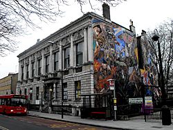
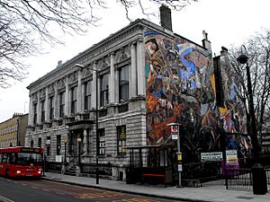
In the 1930s, a group called the British Union of Fascists, led by Sir Oswald Mosley, planned a march. In October 1936, about 3,000 of their supporters marched down Cable Street. But protesters blocked their way with barricades. This event became known as the Battle of Cable Street. A large painting (mural) on the side of the old St George's town hall shows this important moment.
After a lot of damage from bombs during World War II, St George in the East was rebuilt. It became mostly a residential area. New tall apartment buildings were constructed in the 1970s.
Geography of the Parish
The northern edge of the old parish was mostly next to Mile End Old Town. This boundary ran along Commercial Road. To the west, the border with Whitechapel was just before Back Church Lane.
The parish of Wapping was to the south. Wapping acted like a protective area to the west and south. Beyond Wapping were other places like St Botolph Without Aldgate. To the east was the parish of Shadwell. Wapping and Shadwell almost met in the south. This gave the old St George in the East a small front along the Tideway (the tidal part of the River Thames) that was about 53 feet long.
The Shadwell and St George's East railway station was located within the St George parish. A large part of the London Docks was also in the parish. These docks have since been filled in. There is a special area around the Parish church and Town Hall that is protected for its architecture.
Local Government and How it Worked
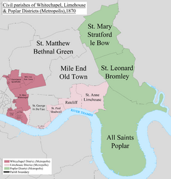
For many centuries, St George in the East was part of Stepney. In 1729, it became its own separate parish. This meant it had its own local government and church administration. By 1881, it had a population of 47,157 people.
From 1855 to 1900, the local government was run by the Vestry of the Parish of St George. A "vestry" was a group of local people who managed the parish's affairs. In 1855, the Vestry of St George in the East was divided into two areas, North and South, because it had more than 2,000 people who paid local taxes.
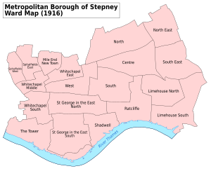
In 1889, the Metropolitan Board of Works was replaced by the London County Council. St George in the East became part of the Metropolitan Borough of Stepney in 1900. It stopped being a civil parish in 1927. The old town hall, where the vestry met, is on Cable Street and is now used for other purposes.
In 1965, the Tower Hamlets Borough Council took over the duties of the former civil parish. Even though the area is no longer a civil parish, there is still a smaller church parish that continues to operate.
Notable Residents
- Lottie Collins, a famous musical hall singer
- Ted "Kid" Lewis, a former World Welterweight boxing champion
 | Selma Burke |
 | Pauline Powell Burns |
 | Frederick J. Brown |
 | Robert Blackburn |


