Commercial Road facts for kids

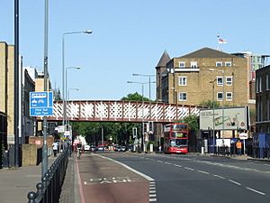
Commercial Road facing the former Limehouse Curve
|
|
| Part of | A13 |
|---|---|
| Length | 1.9 mi (3.1 km) |
| From | Whitechapel High Street |
| To | East India Dock Road |
| Construction | |
| Construction start | 1802 |
| Completion | 1806 |
Commercial Road is a busy street in the London Borough of Tower Hamlets. This area is part of the East End of London. The road is about 1.9 miles (3 kilometers) long. It starts near Aldgate East tube station and goes through Stepney. It ends in Limehouse, where it splits into two other roads.
Commercial Road is an important link. It connects the old part of London, called the City, with a newer business area called Canary Wharf. It is also part of the A13 main road. Along this road, you can find several special buildings. These include the George Tavern, the Troxy cinema, and the Limehouse Town Hall.
Contents
Where Does Commercial Road Go?
Commercial Road begins at a busy spot. This is where it meets Whitechapel High Street. This spot is very close to Aldgate East tube station.
As you travel east, the road crosses several waterways. It goes over the Limehouse Basin. It also crosses the Regent's Canal and the Limehouse Cut. When the road reaches Burdett Road, it divides. The East India Dock Road goes left, and the West India Dock Road goes right.
Many London buses use Commercial Road. These include routes 15, 115, and 135.
History of Commercial Road
Commercial Road was built a long time ago, between 1802 and 1806. Its main purpose was to connect the busy West India Docks and East India Docks to the City of London. This made it easier for goods to be moved. A special law allowed a company to build the road. They could also charge tolls to use it.
The road was built in a straight line. It went across open fields north of another busy road. This area had been cleared by a big fire in 1794. By the 1830s, almost the whole road was lined with houses.
In 1828, a special tramway was built. It was made of granite and helped with traffic. Later, the London and Blackwall Railway was built next to Commercial Road. Many factories also appeared. This made the street very crowded and polluted.
In the 1860s, Commercial Road became a public road. This meant people no longer had to pay tolls. The city government took over its ownership. In 1870, the road was made longer. It stretched west to a place called Gardiner's Corner. This is where it met Whitechapel High Street.
After World War II, in 1943, many parts of the area were damaged. Commercial Road was planned for improvements. Old, crowded areas were cleared. New, modern homes were built. Today, a special area around Commercial Road is protected. This is because it has many historic buildings.
Famous Buildings on Commercial Road
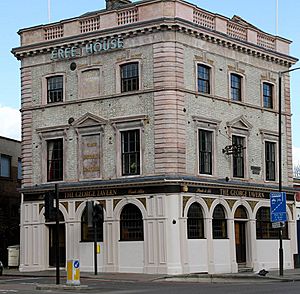
The George Tavern is a very old pub. It was built around 1820-1825. But there was a pub on this spot even earlier, since 1654! It became a protected building in 1973.
Albert Gardens is a pretty area near Commercial Road. It was created in the early 1800s. It has three sides of three-story houses built in the 1840s. These houses look onto a fenced garden. The city bought the land in 1899. They opened the garden to the public in 1906.
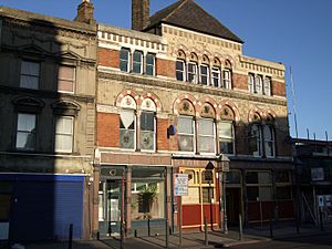
Some buildings at Nos. 440–450 are also protected. They were built in the early 1800s. They are four stories tall with special roofs and doors.
The Troxy Cinema at No. 490 opened in 1933. It was a huge cinema that could hold over 3,000 people. It had a special organ that could rise from the stage! The cinema closed in 1960. It later became a training school for opera singers. After that, it was a bingo hall. It became a protected building in 1991.
Limehouse Town Hall is at No. 646. It was built in 1879. It was damaged during World War II but was rebuilt. It has been used for many things. These include council offices, a museum, a homeless shelter, and an arts center.
The Caird & Rayner Warehouse at Nos. 777–783 was built in 1869. It had a wooden frame with brick walls. In 2010, a fire damaged its roof. It was quickly repaired because it is a protected building.
The Star of the East pub, at No. 805, is also very old. It was built in the early 1800s. It has red brick walls and a slate roof. It was protected in 1973.
The Church of St Mary and St Michael is at No. 340. It was built between 1852 and 1856. It became a protected building in 2001. The Congregation of Jacob Synagogue is at Nos. 351–353. It started in 1903. London's first mosque, the East London Mosque, was on Commercial Road from 1941 to 1975.
You can also find a special old red telephone box. It is outside No. 48 Commercial Road. It was designed in 1927 and became a protected item in 1987.
Traffic on Commercial Road
Commercial Road is a very busy street. It connects the City of London with the East End. There is always a lot of traffic. It can be hard for people to cross the road.
Nearby Roads
- Alie Street
- Cable Street
- Narrow Street
 | Ernest Everett Just |
 | Mary Jackson |
 | Emmett Chappelle |
 | Marie Maynard Daly |


