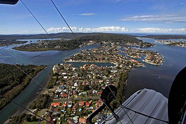
St Huberts Island is a special suburb located on the Central Coast of New South Wales, Australia. It is known as a "canal estate" because it has many waterways and canals that wind through the area. The island is connected to the mainland at a place called Daleys Point. It is part of the Central Coast Council, which is like the local government that helps manage the area.
History of St Huberts Island
People started building homes on St Huberts Island in the early 1970s. A company called Hooker-Rex Developments, which is now known as LJ Hooker Realty, built many of these houses. This development helped shape the island into the community it is today.
Population
In 2016, a count of the people living in the suburb showed that about 1,058 people called St Huberts Island home.
Getting Around
Busways is a company that runs buses through St Huberts Island. There are two main bus routes that help people travel to and from the island:
- 59: This bus goes from Wagstaffe to Woy Woy, passing through Empire Bay.
- 64: This bus travels from Gosford to Woy Woy, going through Point Clare.


