St James Walkway facts for kids
Quick facts for kids St James Walkway |
|
|---|---|

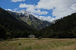
Cannibal Gorge Hut on the St James Walkway in front of peaks of the Freyberg Range
|
|
| Length | 66 km (41 mi) |
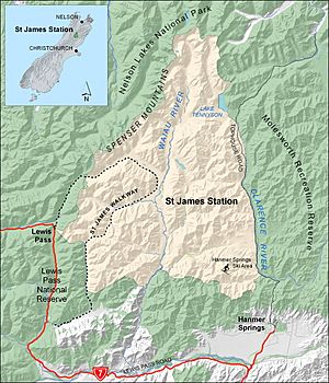
| Location | Lewis Pass National Reserve, St James Station |
| Trailheads | Lewis Pass 42°22′48″S 172°24′04″E / 42.38000°S 172.40117°E Boyle Village 42°31′13″S 172°23′52″E / 42.52026°S 172.39769°E |
| Use | Hiking |
| Highest point | 1,136 m (3,727 ft) |
| Lowest point | 600 m (2,000 ft) |
| Surface | natural |
The St James Walkway is an amazing 66-kilometer (about 41-mile) long track in New Zealand. It's a special kind of hiking trail, often called 'tramping' in New Zealand. This track is found high up in the mountains near Lewis Pass on the South Island. The Department of Conservation looks after it, making sure it's safe and fun for everyone.
Contents
The St James Walkway: A First of Its Kind
The St James Walkway has a cool history! It was the very first walking track in New Zealand to be built in a 'sub-alpine' area. This means it was created in the high mountain regions, just below where trees stop growing. It was a big step for outdoor adventures in the country!
Exploring the St James Walkway
The St James Walkway starts near Lewis Pass and finishes at Boyle Village. Boyle Village is also home to the Boyle River Outdoor Education Centre. The two ends of the track are about 16 kilometers (10 miles) apart by road. Many people prefer to leave their car at Boyle Village because the parking area is considered safer.
Starting Your Adventure: Lewis Pass to Ada Pass
Your journey begins at Lewis Pass, which is about 863 meters (2,831 feet) above sea level. From there, the track goes downhill to a swing bridge over Cannibal Gorge. This gorge is about 720 meters (2,362 feet) high and is formed by a branch of the Maruia River.
The track follows the river to the Cannibal Gorge Hut. After that, you continue to Ada Hut, which is located at Ada Pass. This pass is higher up, at 1,008 meters (3,307 feet).
Along the Ada River to Christopher Hut
From Ada Pass, the walkway follows the Ada River. You'll pass two huts here: the historic Christopher Cullers Hut and the Christopher Hut. The Ada River eventually flows into the Waiau River.
At the Waiau River, the St James Walkway drops down to about 740 meters (2,428 feet). You'll walk near the old Ada homestead in this area.
The Final Stretch: Henry River to Boyle Village
Next, the track goes along the Henry River to Anne Hut. Then, you'll climb to Anne Saddle, which is the highest point on the walkway at 1,136 meters (3,727 feet).
From Anne Saddle, the track follows the Boyle River. You'll pass Rokeby Hut and Boyle Flat Hut before finally reaching Boyle Village. The track ends here at about 600 meters (1,968 feet) above sea level.
Huts Along the Way
There are several huts where you can stay overnight on the St James Walkway.
- Serviced Huts: Five of the huts are 'serviced'. This means they usually have firewood or coal for heating, and they offer between 14 and 20 bunks for sleeping. These huts are Cannibal Gorge, Ada Pass, Christopher, Anne, and Boyle Flat huts.
- Basic Huts: Christopher Cullers Hut and Rokeby Hut are more basic. Christopher Cullers has four bunks, and Rokeby has three.
Connecting with Te Araroa
A big part of the St James Walkway goes through what used to be the St James Station. More than half of this track is also part of Te Araroa. Te Araroa is a very long walking trail that stretches across all of New Zealand! The St James Walkway joins Te Araroa between Christopher and Anne Huts, near the Waiau River.
 | Emma Amos |
 | Edward Mitchell Bannister |
 | Larry D. Alexander |
 | Ernie Barnes |


