
Maruia River facts for kids

The Maruia River is a cool river found in the northwest part of the South Island of New Zealand. It's like a big helper river, joining the even larger Buller River. The Maruia River flows for about 80 kilometres (50 miles) before it meets the Buller River, which happens about eight kilometres (5 miles) west of a town called Murchison.
Contents
Where the River Starts and Flows
The Maruia River begins high up in the Spenser Mountains. At first, it flows towards the southwest. Then, for the last 50 kilometres (31 miles) of its journey, it turns and flows north.
In the upper part of the river's valley, it helps form the western path to the Lewis Pass. This pass is one of the main mountain crossings over the big Southern Alps.
Hot Springs and a Special Gorge
You can find natural hot springs close to the Maruia River in its upper sections. There's even a spa called Maruia Springs about five kilometres (3 miles) west of the Lewis Pass. This spot is about 50 kilometres (31 miles) southeast of Reefton.
A bit further downstream, about three kilometres (2 miles) east of Springs Junction, the Maruia River flows through a deep, narrow place called the Sluice Box gorge. Here, the river cuts through a type of rock called marble, even though most of the rocks around are greywacke. The Sluice Box is where the Alfred River joins the Maruia, and it separates the upper and middle parts of the Maruia Valley. This area is a great spot for camping and is also where the path to Lake Daniell begins.
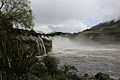
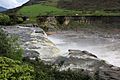
Maruia Falls: A Natural Wonder

Further along the river, about eight kilometres (5 miles) southwest of Murchison, you'll find the amazing Maruia Falls. These waterfalls weren't always here! They were created by a big natural event called the 1929 Murchison earthquake. During this earthquake, a landslide blocked the river's original path, forcing the water to find a new way, which created the beautiful falls we see today.
Images for kids
-
Maruia Falls
-
Maruia Falls


