
St John's, Monmouth facts for kids
Quick facts for kids St John's |
|
|---|---|
.jpg)
St John's in 2017
|
|
| General information | |
| Address | 11 Glendower Street |
| Town or city | Monmouth |
| Country | Wales |
| Coordinates | 51°48′40″N 2°42′53″W / 51.811074°N 2.714656°W |
| Designations | Grade II Listed |
St John's is a very special old house in the town of Monmouth, Wales. It's known as a "grade II listed" building, which means it's important and protected because of its history and unique design. You can find it on Glendower Street, right inside the old medieval town walls that once protected the town.
This house has eight bedrooms and is most famous for its back garden. It features a beautiful metal porch called a Coalbrookdale verandah and a formal walled garden. Both of these parts are also "grade II listed" and are recognized by special groups that protect historic places in Wales.
Contents
A Glimpse into St John's Past

St John's, located at 11 Glendower Street, is sometimes called "one of Monmouth's best-kept secrets." It's an 18th-century building with a rich history. The name "St John's" came from a mistake made by an author named Charles Heath a long time ago. He thought there used to be a monastery of St John nearby.
The house sits on the south side of Glendower Street. This area is within the old medieval walls of Monmouth, which were built around the year 1300. You can even see these walls on old maps of the town, like the one made by John Speed in 1610.
Who Lived Here?
In the mid-1800s, a doctor lived at St John's. He had a special lane for his carriage, a coach house, and stables. This meant he could quickly get to his patients when they needed him.
Later, in 1891, the house was actually called St John's College. A woman named Mrs. Marshall was the principal of this school. By 1901, a retired farmer, Henry Perkins, and his family lived there. In the 1920s and 1930s, a Mrs. Willis was the resident.
The Garden's Story
Old maps, like the 1901 Ordnance Survey map of Monmouthshire, show us what the garden used to look like. It had a conservatory (a glass room for plants), a kitchen garden where food was grown, and even a tennis court!
Today, the tennis court has been replaced by a lawn. Part of the old kitchen garden was sold in the 1920s, and now there's another building there.
Exploring St John's House
The St John's property includes the main house and a smaller building, making a total of eight bedrooms. The front of the main house, facing the street, looks quite simple with two floors. But the back of the house is much grander, with three floors.
Inside the main house, the ground floor has a living room, a dining room, and a kitchen. On the first floor, you'll find three bedrooms. The second floor has three more bedrooms, plus a small room for coats and a cozy den.
The smaller building has its own living room, kitchen, and shower on the ground floor. Upstairs, it has two bedrooms and a bathroom. The front of the house has a special entrance with columns and a pointed roof design. The outside walls are covered in a rough plaster, and the roof is made of slate.
The Amazing Garden and Verandah
The most impressive part of St John's is at the back of the house. There's a beautiful cast-iron verandah from the mid-1800s that stretches along the entire three-story back wall. This verandah was made by a famous company called Coalbrookdale.
Beyond the verandah is a formal walled garden, also from the 1800s. It sits between the house and Chippenham Park to the south. Tall brick walls stand on the east and west sides of the garden. The end of the garden furthest from the house is wider and has a low stone wall and a gate that leads into Chippenham Park.
Protecting History
The main house was officially "grade II listed" on April 9, 1973. Later, the garden, including that wonderful verandah, also became "grade II listed" in 1994. This means they are recognized as important historical sites by organizations like Cadw and the Welsh Historic Gardens Trust, which work to protect Wales's heritage.
Images for kids
-
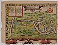
An old map of Monmouth from 1610 by John Speed
