Monmouth town walls and defences facts for kids
Quick facts for kids Monmouth town walls and defences |
|
|---|---|

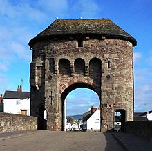
Monnow Bridge Gatehouse, part of the Monmouth town walls and defences
|
|
| General information | |
| Location | Monmouth, Monmouthshire, Wales |
| Opened | circa 1300 |
The Monmouth town walls and defences were a system of walls and gates built in Monmouth, Wales. They were constructed between 1297 and the early 1300s. These walls and gates helped protect the town.
Several gates allowed people to enter or leave Monmouth. These included Wye Bridge Gate, East Gate (also called Dixton Gate), Monk's Gate, and Monnow Bridge Gate. There was also a West Gate on Monnow Street. Today, only the Monnow Bridge Gatehouse is still standing. It has been changed quite a bit from its original look.
Contents
Why Were the Walls Built?
The castle of Monmouth was first built by the Normans in the late 1000s. It was part of their plan to control the Welsh Marches, which is the border area between Wales and England. The castle was built where the Wye and Monnow rivers meet. This was a very important spot.
Around the castle, a small market town grew. In 1267, the castle became owned by Edmund Crouchback. He was the son of King Henry III. Later, his son, Henry de Lancastre, took over.
On August 27, 1297, Henry de Lancastre asked his uncle, King Edward I, for permission to collect a special tax. This tax was called a murage grant. It was given for five years. The money collected from this tax helped pay for the town's medieval walls and gates.
Building the Walls
The murage grant was renewed for another three years in 1315. This suggests that the building project might not have been finished, or that repairs were already needed. The tax was collected on "all wares brought for sale into the town." This means anything brought into town to be sold.
Town walls were important for several reasons. They protected the Anglo-Normans from the Welsh people living nearby, who were sometimes unfriendly. The walls also helped protect the market and made it easier to collect taxes. Building walls and gates also showed how important and powerful the town was. For hundreds of years, the town gates were used to collect tolls from people entering.
We don't know the exact path of all the stone walls. Gate towers were built on Monnow Bridge and at other places. These included Monk's Gate, Dixton Gate, Wye Gate, West Gate, and St Stephen's Gate. St Stephen's Gate led to the castle's outer yard.
Around 1538, a writer named John Leland visited Monmouth. He wrote that a ruined wall and a deep ditch (or fosse) still went around the town.
Monnow Bridge Gatehouse
The Monnow Bridge Gatehouse is the most famous part of Monmouth's old defences. It is connected to the Monnow Bridge. This gatehouse is a scheduled ancient monument and a Grade I listed building. It was officially listed on August 15, 1974.
The bridge itself has three stone arches and was built around 1272. The gatehouse was added to the middle of the bridge between 1297 and 1315. This was when the town's stone walls were being built. The bridge and gate looked very different back then. The bridge was narrower, and the gate had only one archway with a portcullis (a heavy gate that could be lowered). The gatehouse roof was lower and had a parapet with battlements (the notched top of a castle wall). The decorative arches on the front of the gate were added later.
By 1705, the Monnow Bridge Gatehouse needed repairs. The Monmouth Common Council ordered it to be fixed and improved. The battlements were rebuilt as solid walls, and the roof was made higher. This created a two-storey building. A wooden lean-to was also added next to the eastern corner of the gate. Even though the gatehouse was used as a home, part of it was also used as a lock-up or guardroom when needed. The lean-to was taken down in 1815.
In the early and mid-1800s, smaller arches for people walking were cut through the towers on the sides. One arch was cut in 1819 and another in 1845. In 1832, the gatehouse roof was rebuilt again.
Monnow Bridge was an important defence on the west side of town. It connected the area of Overmonnow to Monnow Street, which led to Monmouth Castle and the market. The gatehouse was last used by soldiers in 1839. This was during a time when attacks by the Chartists from Newport were feared, but no attack happened.
In March 2004, a new bridge was opened next to Monnow Bridge. On the same day, the old bridge became only for people walking. This helped traffic flow better on Monnow Street. Today, Monnow Bridge is the only medieval fortified bridge in Britain that still has its gatehouse on the bridge itself.
Other Parts of the Defences
The Monmouth town walls and defences are recorded by Cadw, a Welsh government body that protects historic sites. They also have records with the Glamorgan-Gwent Archaeological Trust. The Monnow Bridge Gatehouse is listed separately because it is so special.
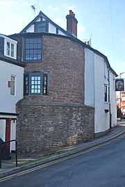
Besides a tower built into the Old Nag's Head pub, there are no other parts of the Monmouth town walls still standing. However, archaeological digs have found parts of the town's old defences.
The gates of Monmouth's walls lasted longer than the walls themselves. Monk's Gate, near the Priory, was removed in 1710. The curved wall at the Masonic Hall entrance might show where it used to be. Wye Gate, at Wye Bridge, is also gone.
Most of the East Gate, also known as Dixton Gate, was taken down in 1770. This was because it was too narrow for coaches to pass through. The only part of the Monmouth town walls and defences still standing (apart from the Monnow Bridge Gatehouse) is the medieval Dixton Gate tower. This tower is now part of the Old Nag's Head public house.
The lower part of the gate tower is older and has a sloped base. The upper part of the red sandstone tower was built in the 1800s. The Old Nag's Head Public House is also a listed building (Grade II*). It received a higher grade because it includes a significant part of the old gate tower.
Rivers and Defences
The town of Monmouth is located between the River Monnow and the River Wye. These two rivers meet just northwest of the town. The town's name comes from its location where the rivers join. "Monmouth" is a shorter way of saying "Monnow's mouth." The Welsh name for the Monnow River, Mynwy, might have meant "fast-flowing."
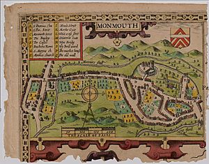
The natural protection from the Monnow and Wye rivers, along with the built walls and defences, kept the town safe. An old map from 1610 shows a rampart (a defensive wall) and a fosse (a ditch) that went from the top of Monnow Street to the River Wye. Then it turned towards the Wye Gate. The rampart and ditch continued to Dixton Gate, and from there, to Monk's Gate and the bank of the River Monnow. After going around the castle, it joined back at the top of Monnow Street.
So, even though we don't know the full path of the walls, they were built very close to the rivers. Also, Clawdd-du, a defensive ditch, surrounded the area of Overmonnow. This added even more protection. However, the Monnow River was quite shallow and narrow. This meant it could be easily crossed upstream. So, while the Monnow Bridge and Gate were built for defence, their main purpose eventually became financial: they were used to collect tolls.
See also
 In Spanish: Murallas y defensas de la ciudad de Monmouth para niños
 | Jewel Prestage |
 | Ella Baker |
 | Fannie Lou Hamer |


