State Line, Franklin County, Pennsylvania facts for kids
Quick facts for kids
State Line,
Franklin County, Pennsylvania |
||
|---|---|---|
|
||
| Country | United States | |
| State | Pennsylvania | |
| County | Franklin | |
| Township | Antrim | |
| Elevation | 710 ft (220 m) | |
| Population
(2020)
|
||
| • Total | 2,804 | |
| • Density | 989/sq mi (382.0/km2) | |
| Time zone | UTC-5 (Eastern (EST)) | |
| • Summer (DST) | UTC-4 (EDT) | |
| ZIP code |
17263
|
|
| Area code(s) | 717 | |
| FIPS code | 42-73848 | |
| GNIS feature ID | 1217375 | |
State Line is a community in Pennsylvania, United States. It is located right next to the border with Maryland. This area is known as a census-designated place (CDP). A CDP is a special area defined by the government for counting people.
State Line is part of Antrim Township in Franklin County. It sits along two important roads: Interstate 81 and U.S. Route 11. These roads connect State Line to nearby towns like Hagerstown, Maryland and Greencastle, Pennsylvania. In 2020, about 2,804 people lived in State Line.
About State Line
State Line is an unincorporated community. This means it does not have its own local government like a city or town. Instead, it is governed by the larger Antrim Township.
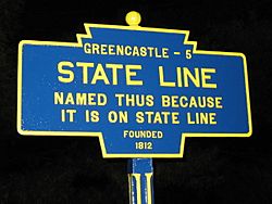
The community's name, State Line, comes from its location. It is right on the border between Pennsylvania and Maryland. This makes it a unique place to live.
History of State Line
State Line was first planned out in 1812. It was originally called Middleburg. This name was chosen because the community was located in the middle of the distance between Greencastle, Pennsylvania, and Hagerstown, Maryland.
Later, the name was changed to State Line. This new name clearly shows its location on the state border. A post office was opened in State Line in 1830. This helped the community grow and connect with other places.
See also
 In Spanish: State Line (condado de Franklin) para niños
 | James Van Der Zee |
 | Alma Thomas |
 | Ellis Wilson |
 | Margaret Taylor-Burroughs |


