Steele Creek, Alaska facts for kids
Quick facts for kids
Steele Creek, Alaska
|
|
|---|---|

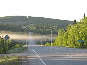
Chena Hot Springs Road runs through the CDP for 11.6 miles (18.7 km), from its intersection with the Steese Expressway to its crossing of the Little Chena River. This view looks eastbound at the intersection of CHSR with Nordale Road.
|
|

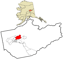
Location within Fairbanks North Star Borough and the state of Alaska
|
|
| Country | United States |
| State | Alaska |
| Area | |
| • Total | 92.91 sq mi (240.63 km2) |
| • Land | 92.89 sq mi (240.59 km2) |
| • Water | 0.01 sq mi (0.04 km2) |
| Elevation | 500 ft (200 m) |
| Population
(2020)
|
|
| • Total | 6,437 |
| • Density | 69.30/sq mi (26.76/km2) |
| Time zone | UTC-9 (Alaska (AKST)) |
| • Summer (DST) | UTC-8 (AKDT) |
| ZIP code |
99712
|
| Area code(s) | 907 |
| FIPS code | 02-72985 |
| GNIS feature ID | 2582718 |
Steele Creek is a special kind of community in Alaska, United States. It is called a census-designated place (CDP). This means it's an area that the government counts for population, but it's not officially a city or town.
Steele Creek is part of the larger Fairbanks, Alaska area. In 2020, about 6,437 people lived there. It is the eighth-largest CDP in all of Alaska.
Contents
Where is Steele Creek Located?
Steele Creek is found in the Fairbanks North Star Borough. It sits northeast of the city of Fairbanks. The community is also east of the Steese Highway.
The area gets its name from Steele Creek itself. This creek flows from north to south through the western part of the community. It starts on Tungsten Hill and flows toward the Chena River.
The community stretches east to the Little Chena River and Iowa Creek. Steele Creek is surrounded by other places. To the east is Two Rivers. To the south is Badger. Fairbanks is to the southwest. Farmers Loop is to the west. And Fox is to the northwest.
How Big is Steele Creek?
Steele Creek covers a total area of about 240.5 square kilometers (about 92.9 square miles). Most of this area is land. Only a tiny part, about 0.01 square kilometers (0.004 square miles), is water.
How Many People Live in Steele Creek?
| Historical population | |||
|---|---|---|---|
| Census | Pop. | %± | |
| 2010 | 6,662 | — | |
| 2020 | 6,437 | −3.4% | |
| U.S. Decennial Census | |||
In 2010, there were 6,662 people living in Steele Creek. By 2020, the population had slightly decreased to 6,437 people.
The people living in Steele Creek come from different backgrounds. In 2010, most residents (about 87.4%) were White. Other groups included Black or African American (0.8%), Native American (3.8%), Asian (0.9%), and Pacific Islander (0.2%). About 1.1% were from other races, and 5.9% were from two or more races. About 3.2% of the population identified as Hispanic or Latino.
See also
 In Spanish: Steele Creek (Alaska) para niños
 | William L. Dawson |
 | W. E. B. Du Bois |
 | Harry Belafonte |

