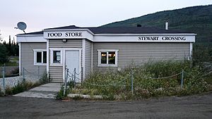
Stewart Crossing facts for kids
Stewart Crossing is a small community located in Yukon, Canada. It sits right on the Stewart River. This spot is about 179 kilometers (that's about 111 miles) east of Dawson City along the Klondike Highway. It's also near where the Klondike Highway meets the Silver Trail, and it's about 53 kilometers (around 33 miles) southwest of Mayo.
Stewart Crossing is mainly known for a camp that helps maintain the highway and a lodge where travelers can stop. The name "Stewart Crossing" comes from when the Klondike Highway, then called the Mayo Road, used to cross the Stewart River by a ferry. This ferry operated from 1950 until a bridge was built in the mid-1950s.
Where is Stewart Crossing?
Stewart Crossing is in the vast and beautiful territory of Yukon, Canada. It's a key point on the Klondike Highway, which is an important road for travel in the region. Its location by the Stewart River makes it a notable landmark for people driving through this part of Canada.
What's the Weather Like?
The weather in Stewart Crossing changes a lot throughout the year, like many places in Yukon. It has very cold winters and warm summers.
| Climate data for Stewart Crossing | |||||||||||||
|---|---|---|---|---|---|---|---|---|---|---|---|---|---|
| Month | Jan | Feb | Mar | Apr | May | Jun | Jul | Aug | Sep | Oct | Nov | Dec | Year |
| Record high °C (°F) | 10.0 (50.0) |
12.0 (53.6) |
13.0 (55.4) |
23.5 (74.3) |
32.0 (89.6) |
34.0 (93.2) |
33.0 (91.4) |
32.0 (89.6) |
26.1 (79.0) |
22.0 (71.6) |
12.0 (53.6) |
11.0 (51.8) |
34.0 (93.2) |
| Mean daily maximum °C (°F) | −23.5 (−10.3) |
−13.7 (7.3) |
−2.8 (27.0) |
10.0 (50.0) |
— | 22.5 (72.5) |
— | 20.6 (69.1) |
13.1 (55.6) |
−0.3 (31.5) |
−16.7 (1.9) |
−12.9 (8.8) |
−0.4 (31.3) |
| Daily mean °C (°F) | −27.8 (−18.0) |
−19.9 (−3.8) |
−10.9 (12.4) |
1.5 (34.7) |
— | 14.6 (58.3) |
— | 13.4 (56.1) |
7.0 (44.6) |
−5.0 (23.0) |
−21.3 (−6.3) |
−19.2 (−2.6) |
−6.8 (19.8) |
| Mean daily minimum °C (°F) | −31.2 (−24.2) |
−26.1 (−15.0) |
−18.4 (−1.1) |
−7.0 (19.4) |
— | 6.8 (44.2) |
— | 6.0 (42.8) |
1.0 (33.8) |
−10.0 (14.0) |
−24.8 (−12.6) |
−25.2 (−13.4) |
−12.9 (8.8) |
| Record low °C (°F) | −55.0 (−67.0) |
−52.0 (−61.6) |
−46.0 (−50.8) |
−34.0 (−29.2) |
−12.0 (10.4) |
−3.5 (25.7) |
−0.6 (30.9) |
−6.0 (21.2) |
−22.0 (−7.6) |
−35.0 (−31.0) |
−48.5 (−55.3) |
−55.5 (−67.9) |
−55.5 (−67.9) |
| Average precipitation mm (inches) | 23.3 (0.92) |
13.7 (0.54) |
10.4 (0.41) |
8.3 (0.33) |
27.6 (1.09) |
39.4 (1.55) |
54.2 (2.13) |
46.0 (1.81) |
35.7 (1.41) |
24.3 (0.96) |
28.1 (1.11) |
25.7 (1.01) |
336.5 (13.25) |
| Average rainfall mm (inches) | 0.0 (0.0) |
0.0 (0.0) |
0.1 (0.00) |
2.2 (0.09) |
27.4 (1.08) |
39.4 (1.55) |
54.2 (2.13) |
45.7 (1.80) |
34.2 (1.35) |
9.8 (0.39) |
0.3 (0.01) |
0.0 (0.0) |
213.3 (8.40) |
| Average snowfall cm (inches) | 23.2 (9.1) |
13.7 (5.4) |
10.3 (4.1) |
6.1 (2.4) |
0.2 (0.1) |
0.0 (0.0) |
0.0 (0.0) |
0.4 (0.2) |
1.5 (0.6) |
14.5 (5.7) |
27.8 (10.9) |
25.7 (10.1) |
123.2 (48.5) |
| Average precipitation days (≥ 0.2 mm) | 6.6 | 4.9 | 3.4 | 2.9 | 7.9 | 9.8 | 12.4 | 9.8 | 9.5 | 8.6 | 8.0 | 7.6 | 91.2 |
| Average rainy days (≥ 0.2 mm) | 0.0 | 0.0 | 0.1 | 0.8 | 7.8 | 9.8 | 12.4 | 9.8 | 8.9 | 3.0 | 0.1 | 0.0 | 52.6 |
| Average snowy days (≥ 0.2 cm) | 6.6 | 4.9 | 3.4 | 2.0 | 0.1 | 0.0 | 0.0 | 0.1 | 0.6 | 5.8 | 7.9 | 7.6 | 38.8 |
| Source: Environment Canada Canadian Climate Normals 1981–2010 | |||||||||||||
Winters can be extremely cold, with temperatures often dropping far below freezing. Summers, however, are much milder and can even be quite warm. The area also gets a good amount of precipitation, which means both rain and snow throughout the year.
How Many People Live There?
Stewart Crossing is a very small community. The number of people living there has changed over the years.
| Federal census population history of Stewart Crossing | ||
|---|---|---|
| Year | Pop. | ±% |
| 1981 | 20 | — |
| 1986 | 40 | +100.0% |
| 1991 | 42 | +5.0% |
| 1996 | 42 | +0.0% |
| 2001 | 40 | −4.8% |
| 2006 | 35 | −12.5% |
| 2011 | 25 | −28.6% |
| 2016 | 17 | −32.0% |
| 2021 | 10 | −41.2% |
| Source: Statistics Canada |
||
According to the 2021 Census, only 10 people lived in Stewart Crossing. They lived in 5 homes, out of 20 total buildings that could be homes. This number was a bit lower than in 2016, when 17 people lived there. The area of Stewart Crossing is about 28.68 square kilometers (around 11 square miles). This means that in 2021, there was about 0.3 people living per square kilometer. This is a very low population density, meaning there's a lot of space for each person!
 | Sharif Bey |
 | Hale Woodruff |
 | Richmond Barthé |
 | Purvis Young |


