
Stiles, Texas facts for kids
Quick facts for kids
Stiles, Texas
|
|
|---|---|

Abandoned Reagan County Courthouse at Stiles
|
|

Stiles, Texas
Location in Texas

Stiles, Texas
Location in the United States
|
|
| Country | |
| State | |
| County | Reagan |
| Physiographic region | West Texas |
| Founded | 1894 |
| Elevation | 2,549 ft (777 m) |
| Population
(2000)
|
|
| • Total | 4 |
| Time zone | UTC-6 (Central (CST)) |
| • Summer (DST) | UTC-5 (CDT) |
| Area code | 325 |
Stiles is a ghost town located in Reagan County, Texas, in the United States. It's about 18 miles north of a town called Big Lake. Stiles was founded in 1894. When Reagan County was created in 1903, Stiles was the only town around, so it became the county seat.
However, things changed when the railroad was built. It didn't go through Stiles. Then, oil was found near Big Lake, which grew much faster. Because of this, Big Lake replaced Stiles as the county seat in 1925.
Stiles Courthouse
The old Reagan County Courthouse was built in 1911. Its ruins can still be seen today. You can find them just off Texas State Highway 137, on Stiles Courthouse Loop. This loop is between Big Lake and Texas State Highway 158.
A builder named William Martin constructed the courthouse using local stone. In 1998, the building was damaged by several fires.
Stiles Cemetery
The Stiles Cemetery is located off of SH 137. It's across the Centralia Draw, southwest of the old courthouse. The cemetery was started around 1903.
The land for the cemetery was once owned by early settlers G. W. and Lizzie Stiles. This burial ground tells a lot about frontier life. It holds the graves of cowboys who died in accidents. There's also a veteran from the Spanish–American War buried here. Other graves belong to people who died from shootings, rattlesnake bites, or a disease called epidemic dysentery. Many of the people buried here were pioneers who lived quiet lives. The 3-acre plot was used for many years before it was officially given to the county in 1920. It was donated by J. D. Wagner, an adventurous man who lived in both Texas and South America.
Centralia Draw
Stiles is located within an old stream channel known as Centralia Draw. A "draw" is a dry streambed or gully that only carries water after heavy rain. This draw begins about 13 miles northeast of Rankin in eastern Upton County.
It then stretches east for 43 miles. It goes across Upton, Reagan, and Irion counties. Finally, it reaches the Middle Concho River. Today, Centralia Draw is usually dry for most of the year. Water only flows through it during short periods of heavy rain. However, there is evidence that a more active, spring-fed stream once flowed here. This stream helped to create the wide valley we see today.
-
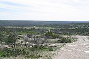
Broad valley of Centralia Draw just south of Stiles.

