Stoke River facts for kids
Quick facts for kids Stoke River |
|
|---|---|

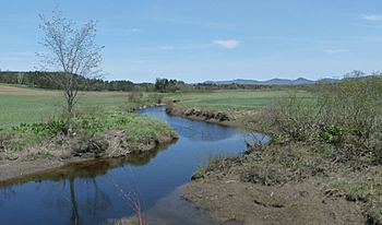
Stoke River as seen from Carrier Road with the Stoke Mountains in the background.
|
|
| Native name | Rivière Stoke |
| Country | Canada |
| Province | Quebec |
| Region | Chaudière-Appalaches |
| MRC | Le Haut-Saint-François Regional County Municipality, Les Sources Regional County Municipality, Le Val-Saint-François Regional County Municipality |
| Municipality | Dudswell and Saint-Camille, Stoke, Saint-Georges-de-Windsor, Val-Joli and Windsor |
| Physical characteristics | |
| Main source | Brabant Lake Dudswell 426 m (1,398 ft) 45°38′58″N 71°38′14″W / 45.649528°N 71.63714°W |
| River mouth | Saint-François River Windsor 264 m (866 ft) 45°34′46″N 71°57′45″W / 45.57944°N 71.9625°W |
| Length | 36.1 km (22.4 mi) |
| Basin features | |
| Progression | Saint-François River, St. Lawrence River |
| Tributaries |
|
The Stoke River (also known as rivière Stoke in French) is a river in Quebec, Canada. It flows into the Saint-François River, which is a larger river. The Stoke River is located in the Estrie region, which is on the South Shore of the St. Lawrence River.
The river flows through several different areas:
- The Le Haut-Saint-François Regional County Municipality, specifically the town of Dudswell.
- The Le Val-Saint-François Regional County Municipality, including the towns of Stoke and Val-Joli.
Contents
Where Does the Stoke River Flow?
The Stoke River has a path that winds through the landscape. To understand its journey, it helps to know about the other rivers and lakes nearby.
Neighboring Waterways
The main water areas close to the Stoke River are:
- To the north: The Watopeka River and a lake called Lac Boissonneault.
- To the east: The Watopeka River again.
- To the south: The Saint-François River.
- To the west: The Saint-François River.
The River's Starting Point
The Stoke River begins at Brabant Lake. This lake is about 426 metres (1,398 ft) (around 1,398 feet) above sea level. You can find Brabant Lake in the town of Dudswell. It's northwest of the village of "Saint-Adolphe-de-Dudswell" and Lac d'Argent. It's also east of Saint-Camille.
The River's Journey
From Brabant Lake, the Stoke River flows for about 36.1 kilometres (22.4 mi) (around 22.4 miles). Here's how its journey unfolds:
- It flows south for about 0.9 kilometres (0.56 mi) (0.6 miles).
- Then, it turns southwest for 2.9 kilometres (1.8 mi) (1.8 miles), reaching Route 255.
- It continues southwest for another 5.8 kilometres (3.6 mi) (3.6 miles), reaching the border between Dudswell and Stoke.
- The river flows southwest for 13.5 kilometres (8.4 mi) (8.4 miles), following Route 216. It passes through a small area called Duplin and goes near the village of Stoke.
- Next, it travels southwest for 1.3 kilometres (0.81 mi) (0.8 miles), passing northwest of Stoke village. Here, it meets the water flowing out of Stoke Lake.
- Finally, the river flows west for 11.7 kilometres (7.3 mi) (7.3 miles). This part of the river has many bends and curves. It flows between two mountains, "Le dos de cheval" and "Mont-Carrier." It also collects water from the Godbout stream. The Stoke River then joins the Watopeka River.
The Stoke River ends its journey by emptying into the east bank of the Watopeka River.
What's in a Name?
The name "Rivière Stoke" was officially recorded on December 5, 1968. This was done by the Commission de toponymie du Québec, which is like a special group that names places in Quebec.
 | Delilah Pierce |
 | Gordon Parks |
 | Augusta Savage |
 | Charles Ethan Porter |

