
Watopeka River facts for kids
Quick facts for kids Watopeka River |
|
|---|---|

Watopeka River
|
|
| Native name | Rivière Watopeka |
| Country | Canada |
| Province | Quebec |
| Region | Chaudière-Appalaches |
| MRC | Le Haut-Saint-François Regional County Municipality, Les Sources Regional County Municipality, Le Val-Saint-François Regional County Municipality |
| Municipality | Dudswell and Saint-Camille, Stoke, Saint-Georges-de-Windsor, Val-Joli and Windsor |
| Physical characteristics | |
| Main source | Lake Watopeka Dudswell 303 m (994 ft) 45°38′20″N 71°45′41″W / 45.63890°N 71.76140°W |
| River mouth | Saint-François River Windsor 264 m (866 ft) 45°33′48″N 72°00′20″W / 45.56333°N 72.00555°W |
| Length | 26.7 km (16.6 mi) |
| Basin features | |
| Progression | Saint-François River, St. Lawrence River |
| Tributaries |
|
The Watopeka River (which is rivière Watopeka in French) is a river in Quebec, Canada. It flows into the Saint-François River. This river is part of the larger St. Lawrence River system.
The Watopeka River flows through several towns and areas. These include:
- Dudswell
- Saint-Camille
- Stoke
- Saint-Georges-de-Windsor
- Val-Joli
- Windsor
Contents
Where the Watopeka River Flows
_-_panoramio.jpg)
The Watopeka River starts at Lake Watopeka. This lake is located in Dudswell. It is near the borders of Saint-Camille and Stoke.
The River's Journey
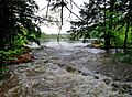
The Watopeka River flows for about 26.7 kilometers (16.6 miles). Its journey can be split into two main parts.
Upper Part of the River
From Lake Watopeka, the river first flows west for about 0.7 kilometers (0.4 miles) through Saint-Camille. Then, it winds through Stoke for about 7.4 kilometers (4.6 miles).
Next, it flows west for 4.5 kilometers (2.8 miles) through Saint-Georges-de-Windsor. Here, it crosses an unnamed lake for 1.0 kilometer (0.6 miles). A small stream called Bruneau also joins the river here.
The river then flows southwest for 3.2 kilometers (2.0 miles) into Saint-Claude. It crosses Lac Boissonneault for 7.6 kilometers (4.7 miles). Finally, it flows southwest for 4.2 kilometers (2.6 miles) through Val-Joli. This part ends where the Stoke River joins it.
Lower Part of the River
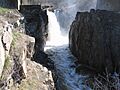
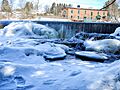
After the Stoke River joins, the Watopeka River continues for about 5.5 kilometers (3.4 miles). It flows past the Charles dam.
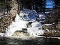
It then flows southwest through the city of Windsor. Along this path, it collects water from the Péloquin stream. It also flows around Île Rouillard and passes two more dams, La Poudrière and Watopeka. The river also goes through the Poudrière rapids.
The Watopeka River eventually empties into the Saint-François River in the southern part of Windsor. This is about 20 kilometers (12 miles) downstream from Sherbrooke.
What's in a Name?
The name "Watopeka" comes from the Abenaki language. The Abenaki are an Indigenous people of North America. The word "Wdopikak" means "where alders are found." Alders are a type of tree or shrub.
Some people think Watopeka might mean "pearl river." This is because of the rapids in the river, which might look like pearls. Over time, the name has been spelled in many different ways. This happened as English and French speakers used the name.
For example, in 1801, a map showed it as "Ottopikak River." Later, in 1931, a French map called it "Wattopekan River." Other old documents used spellings like Watopéca, Wattopeka, and Wattopikaw. The river was also sometimes called "Le Grand Ruisseau" or "The Brook."
The official name, Watopeka River, was registered on December 5, 1968. This was done by the Commission de toponymie du Québec, which is like a naming committee for places in Quebec.
Images for kids
-
-
-
-
-

.


