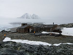
Stonington Island facts for kids
Stonington Island is a small, rocky island located in a cold, icy place called Marguerite Bay, off the west coast of Graham Land, Antarctica. It's about 1.8 kilometers northeast of Neny Island. The island is about 0.75 kilometers long and 0.37 kilometers wide, covering an area of 20 hectares. Long ago, it was connected to the mainland by a big slope of snow from the Northeast Glacier. Its highest point is a small hill called Anemometer Hill, which is 25 meters tall.
Contents
Island History and Explorers
Stonington Island became an important spot for explorers! In 1939, the United States Antarctic Service (USAS) Expedition set up their "East Base" here. The island got its name from Stonington, Connecticut, a town in the United States. This was the home port of the ship Hero, which Captain Nathaniel Palmer used when he first saw the Antarctic continent in 1820.
Station E: A British Base
The island was also home to the British Antarctic Survey (BAS) and their base, known as Station E. It was also used by the Ronne Antarctic Research Expedition. Many important mapping trips in the Antarctic Peninsula during the 1940s started from here. Station E was used until February 23, 1975. The main building was called Trepassey House, and it was cleaned and fixed up in 1992. These old buildings are now protected under the Antarctic Treaty System, which helps preserve important places in Antarctica.
Protected Historic Sites
Some areas on Stonington Island are protected because of their history. This includes the buildings and items from the East Base, which were used by two US expeditions that stayed through the winter. This protected area stretches about 1100 meters from north to south, from the beach to the Northeast Glacier. It is also about 550 meters wide. This area has been named a Historic Site or Monument (HSM 55) by the Antarctic Treaty Consultative Meeting (ATCM).
The British Station E is also very important historically. It shows us about early exploration and the later work of the British Antarctic Survey in the 1960s and 1970s. It has also been named a Historic Site or Monument (HSM 64) by the ATCM.
Island Environment
Stonington Island Climate
Stonington Island has a very cold climate, as you might expect for Antarctica! Here's a look at the weather:
| Climate data for Stonington Islands | |||||||||||||
|---|---|---|---|---|---|---|---|---|---|---|---|---|---|
| Month | Jan | Feb | Mar | Apr | May | Jun | Jul | Aug | Sep | Oct | Nov | Dec | Year |
| Record high °C (°F) | 6 (43) |
7 (45) |
8 (46) |
7 (45) |
4 (39) |
7 (45) |
4 (39) |
4 (39) |
5 (41) |
6 (43) |
8 (46) |
7 (45) |
8 (46) |
| Mean daily maximum °C (°F) | 3 (37) |
1 (34) |
−2 (28) |
−4 (25) |
−6 (21) |
−8 (18) |
−8 (18) |
−9 (16) |
−8 (18) |
−4 (25) |
−3 (27) |
2 (36) |
−4 (25) |
| Mean daily minimum °C (°F) | −3 (27) |
−4 (25) |
−8 (18) |
−10 (14) |
−14 (7) |
−17 (1) |
−18 (0) |
−19 (−2) |
−16 (3) |
−13 (9) |
−9 (16) |
−3 (27) |
−11 (12) |
| Record low °C (°F) | −12 (10) |
−11 (12) |
−35 (−31) |
−27 (−17) |
−36 (−33) |
−37 (−35) |
−36 (−33) |
−37 (−35) |
−39 (−38) |
−29 (−20) |
−20 (−4) |
−13 (9) |
−39 (−38) |
| Average precipitation mm (inches) | 10 (0.4) |
15 (0.6) |
25 (1.0) |
25 (1.0) |
43 (1.7) |
28 (1.1) |
33 (1.3) |
25 (1.0) |
41 (1.6) |
43 (1.7) |
23 (0.9) |
5 (0.2) |
316 (12.5) |
| Average precipitation days | 3 | 4 | 7 | 7 | 9 | 6 | 7 | 7 | 7 | 8 | 5 | 1 | 71 |
| Source: [1] | |||||||||||||
Important Bird Area
A special area of 500 hectares on the island has been named an Important Bird Area (IBA) by BirdLife International. This means it's a very important place for birds! About 135 pairs of imperial shags, a type of bird, come here to build their nests and raise their young. Other birds that breed on the island include south polar skuas and Antarctic terns.
See also
 In Spanish: Isla Stonington para niños
 | William L. Dawson |
 | W. E. B. Du Bois |
 | Harry Belafonte |


