Stonington, Connecticut facts for kids
Quick facts for kids
Stonington, Connecticut
|
||
|---|---|---|
|
Town
|
||
| Town of Stonington | ||
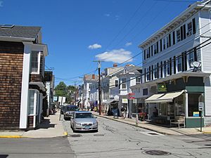
Stonington, Connecticut, August 2012
|
||
|
||
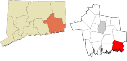
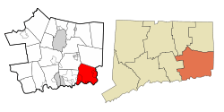 New London County and Connecticut New London County and Connecticut |
||
| Country | ||
| U.S. state | ||
| County | New London | |
| Region | Southeastern CT | |
| Settled | 1649 | |
| Established | 1662 | |
| Government | ||
| • Type | Selectman-town meeting | |
| Area | ||
| • Total | 48.98 sq mi (126.85 km2) | |
| • Land | 38.66 sq mi (100.12 km2) | |
| • Water | 10.32 sq mi (26.72 km2) | |
| Elevation | 75 ft (23 m) | |
| Population
(2020)
|
||
| • Total | 18,335 | |
| • Density | 374.34/sq mi (144.541/km2) | |
| Time zone | UTC-5 (Eastern) | |
| • Summer (DST) | UTC-4 (Eastern) | |
| ZIP Codes |
06355, 06378, 06379
|
|
| Area code(s) | 860/959 | |
| FIPS code | 09-73770 | |
| GNIS feature ID | 0213513 | |
Stonington is a town in New London County, Connecticut, United States. It includes the area known as Stonington Borough. Other villages within the town are Pawcatuck, Lords Point, and Wequetequock. The eastern parts of Mystic and Old Mystic are also in Stonington. This town is part of the Southeastern Connecticut Planning Region. In 2020, about 18,335 people lived here.
Contents
History of Stonington
Early European Settlers
The first European settlers arrived in Stonington around 1649. These included William Chesebrough and Walter Palmer in Wequetequock. Thomas Minor settled in Quiambaug, and Thomas Stanton in Pawcatuck. Thomas Stanton set up a trading post in Pawcatuck in 1649.
Naming the Town
The land where Stonington now stands once belonged to the Pequot people. They called parts of the area Paquatuck and Mistack. In 1658, Massachusetts named the area "Souther Towne" or Southerton. It officially became part of Connecticut in 1662. In 1665, Southerton was renamed "Mistick". Finally, in 1666, it was named Stonington, which means "stony town". The town of North Stonington was created from Stonington in 1807.
The Battle of Stonington (1814)
During the War of 1812, a British fleet arrived off Stonington Point. On August 9, 1814, Sir Thomas Hardy demanded the town surrender. The town leaders bravely refused, saying they would defend the town "to the last extremity."
The British ships then attacked Stonington for three days. American forces in the town fought back with two large 18-pounder cannons. Only one American person was hurt, an elderly woman who was already very sick. The British ships had several people killed and wounded. They sailed away on August 12.
The poet Philip Freneau wrote a poem about this battle. It made fun of the British attack, saying they mostly hit a barn and hurt some farm animals.
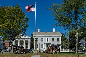
A memorial stands in Cannon Square in Stonington Borough. It has the two 18-pounder cannons used in the battle. This memorial remembers the 1814 attack, known as the Battle of Stonington.
Stonington's Economy and Growth
From the 1790s, Stonington's economy grew. Its harbor became a base for American ships that hunted seals. They hunted whales near Patagonia and sold the animal skins in China. In 1820, six sealing ships from Stonington sailed to hunt whales. On November 16, 1820, Nathaniel Palmer first saw Palmer Land, which was named after him.
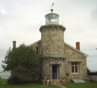
The Stonington Harbor Light is a stone lighthouse built in 1840. In 1925, it became the first lighthouse museum in America. During the 1800s, Stonington had a small fleet for fishing, whaling, and sealing. They traded with the West Indies. This trade was so important that Stonington became a port of entry in 1842. Many people from Portugal came to the village from the Azores islands on whaling ships. The small granite Customs House is near Cannon Square.
The Groton and Stonington Street Railway was a trolley line built in 1904. It served the Stonington area. The trolley was removed in 1928 and replaced by buses. In recent years, many people have bought and fixed up old houses in Stonington Borough as second homes. Stonington is now home to Connecticut's last commercial fishing fleet.
Geography of Stonington
The town of Stonington covers about 129.6 square kilometers (48.98 square miles). Most of this is land, about 100.2 square kilometers (38.66 square miles). The rest, about 29.4 square kilometers (10.32 square miles), is water.
Interestingly, the states of New York, Connecticut, and Rhode Island meet at a single point in the waters off Stonington.
Main Communities in Stonington
Stonington includes several important communities:
- Lords Point (ZIP Code 06378)
- Mystic (ZIP Code 06355) - part of this village is also in the town of Groton.
- Smaller areas within Mystic include Enders Island, Greenmanville, Mason's Island, Pequotsepos, Quiambaug, and Seaport Heights.
- Old Mystic (ZIP Code 06372) - mostly in the town of Groton.
- Smaller areas include Quaketaug Hill and Wolf Neck.
- Pawcatuck (ZIP Code 06379)
- Smaller areas include Anguilla, Anguilla Acres, Blueberry Hill, Brookside, Castle Hill, Clarksville, Downerville, Hinckley Hill, Lower Pawcatuck, Oak Hill Gardens, Solomonville, Stillmanville, The Highlands, Berry Hill, and Wequetequock Hill.
- Stonington Borough (ZIP Code 06378)
- Wequetequock (ZIP Code 06379)
Other smaller areas are Deans Mill, Grand View Park, Greenhaven, Ledward Island, Ram Island, Road Church District, and Wamphassuc Point.
Stonington's Climate
Stonington has a humid continental climate. This means it has warm summers and cold winters. It is in hardiness zones 6b/7a, which helps gardeners know what plants will grow well there.
| Climate data for Stonington, Connecticut | |||||||||||||
|---|---|---|---|---|---|---|---|---|---|---|---|---|---|
| Month | Jan | Feb | Mar | Apr | May | Jun | Jul | Aug | Sep | Oct | Nov | Dec | Year |
| Mean daily maximum °F (°C) | 38 (3) |
39 (4) |
47 (8) |
56 (13) |
66 (19) |
75 (24) |
81 (27) |
80 (27) |
73 (23) |
62 (17) |
53 (12) |
43 (6) |
59 (15) |
| Mean daily minimum °F (°C) | 20 (−7) |
22 (−6) |
29 (−2) |
38 (3) |
48 (9) |
57 (14) |
63 (17) |
62 (17) |
55 (13) |
43 (6) |
35 (2) |
26 (−3) |
42 (5) |
| Average precipitation inches (mm) | 4.39 (112) |
3.54 (90) |
4.46 (113) |
4.23 (107) |
3.79 (96) |
3.67 (93) |
3.31 (84) |
4.46 (113) |
4.06 (103) |
3.98 (101) |
4.51 (115) |
4.32 (110) |
48.72 (1,237) |
| Source: The Weather Channel | |||||||||||||
People of Stonington
| Historical population | |||
|---|---|---|---|
| Census | Pop. | %± | |
| 1820 | 3,036 | — | |
| 1840 | 3,898 | — | |
| 1850 | 5,753 | 47.6% | |
| 1860 | 5,827 | 1.3% | |
| 1870 | 6,313 | 8.3% | |
| 1880 | 7,355 | 16.5% | |
| 1890 | 7,184 | −2.3% | |
| 1900 | 8,540 | 18.9% | |
| 1910 | 9,154 | 7.2% | |
| 1920 | 10,236 | 11.8% | |
| 1930 | 11,025 | 7.7% | |
| 1940 | 11,002 | −0.2% | |
| 1950 | 11,801 | 7.3% | |
| 1960 | 13,969 | 18.4% | |
| 1970 | 15,940 | 14.1% | |
| 1980 | 16,220 | 1.8% | |
| 1990 | 16,919 | 4.3% | |
| 2000 | 17,906 | 5.8% | |
| 2010 | 18,545 | 3.6% | |
| 2020 | 18,335 | −1.1% | |
| U.S. Decennial Census | |||
In 2000, there were 17,906 people living in Stonington. There were 7,665 households, and 4,897 families. About 26.2% of households had children under 18. The average household had 2.31 people. The average family had 2.88 people.
The population was spread out by age. About 21.7% were under 18. About 17.5% were 65 or older. The average age was 42 years old. For every 100 females, there were about 94.5 males.
The median income for a household was $52,437. For a family, it was $63,431. About 5.0% of the population lived below the poverty line.
Historic Places in Stonington
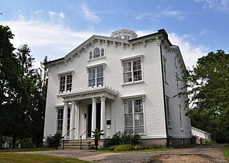
Many buildings and areas in Stonington are listed on the National Register of Historic Places. This means they are important for their history or architecture.
- Capt. Nathaniel B. Palmer House – This house is at 40 Palmer Street. It was added to the list in 1996.
- Mechanic Street Historic District – This area in Pawcatuck has many historic buildings. It was added in 1988.
- Mystic Bridge Historic District – This part of downtown Mystic was added in 1979.
- Pequotsepos Manor – This historic home is at 120 Pequotsepos Road in Mystic. It was added in 1979.
- Rossie Velvet Mill Historic District – This area in Mystic was once a mill. It was added in 2007.
- Stanton-Davis Homestead Museum – Also called the Robert Stanton House, it's at 576 Greenhaven Road in Pawcatuck. It was added in 1979.
- Stonington Harbor Light – This lighthouse at 7 Water Street was added in 1976.
- Stonington Borough School – This old school building at 25 Orchard Street was added in 1978.
- Whitehall Mansion – This mansion at 42 Whitehall Avenue in Mystic was added in 1979.
- William Clark Company Thread Mill – This old mill in Pawcatuck was added in 2008.
Famous People from Stonington
Many notable people have connections to Stonington:
- Peter Benchley (1940–2006), author of the famous book Jaws
- Stephen Vincent Benét (1898–1943), a well-known poet
- Ruth Buzzi (born 1936), a funny comedian and actress
- Edmund Fanning (1769–1841), an explorer
- Nathaniel Fanning (1755–1805), a hero from the Revolutionary War
- Sergio Franchi (1926–1990), an Italian singer
- Wally Kopf (1899–1979), a baseball player for the New York Giants
- J. D. McClatchy (1945–2018), a poet and writer for operas
- James Merrill (1926–1995), a poet who won a Pulitzer Prize
- Nathaniel Palmer (1799–1877), an explorer, ship captain, and ship designer
- Greg "Fossilman" Raymer (born 1964), the 2004 World Series of Poker champion
- Rob Simmons (born 1943), a former congressman
- Grace Zaring Stone (1891–1991), a novelist
- Edward Trumbull (1884–1968), a painter
- William Chesebrough (1594-1667), a town founder, farmer, merchant, and politician
See also
 In Spanish: Stonington (Connecticut) para niños
 | Aurelia Browder |
 | Nannie Helen Burroughs |
 | Michelle Alexander |


