Stony Brook (Green Brook tributary) facts for kids
Quick facts for kids Stony Brook |
|
|---|---|

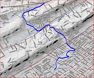
Stony Brook map
|
|
| Country | United States |
| Physical characteristics | |
| Main source | 40°39′12″N 74°27′11″W / 40.65333°N 74.45306°W |
| River mouth | 59 ft (18 m) 40°36′28″N 74°26′52″W / 40.60778°N 74.44778°W |
| Basin features | |
| Progression | Green Brook, Bound Brook, Raritan River |
| River system | Raritan River system |
| Tributaries |
|
The Stony Brook is a small stream, also called a tributary, located in central New Jersey, United States. It flows into a larger stream called the Green Brook.
Where Does Stony Brook Start and End?
The Stony Brook begins its journey at 40°39′12″N 74°27′11″W / 40.65333°N 74.45306°W. This spot is close to where Hillcrest Road meets I-78.
The Brook's Path Through New Jersey
From its start, the brook flows towards the southeast. It crosses Stirling Road along the way. After that, it makes a turn to the southwest.
The Stony Brook then changes direction again, heading northeast. It flows into a body of water called Watchung Lake. Inside the lake, it meets two other small streams.
After leaving Watchung Lake, the brook continues southeast. It travels through the town of Watchung. It also passes through a narrow area called the Stony Brook Gorge. This gorge is found in the first Watchung Mountain. The brook also flows over the beautiful Wetumpka Falls.
Joining Other Streams
The Stony Brook crosses under Route 22. Soon after, it joins another stream called the Crab Brook. The Crab Brook is the only stream that flows into the Stony Brook.
The brook then crosses Greenbrook Road and turns south. It flows under West End Avenue. Finally, the Stony Brook empties into the Green Brook. This happens at 40°36′28″N 74°26′52″W / 40.60778°N 74.44778°W, inside Green Brook Park.
 | Frances Mary Albrier |
 | Whitney Young |
 | Muhammad Ali |

