
Stort Navigation facts for kids
Quick facts for kids Stort Navigation |
|
|---|---|

The navigation approaching Roydon
|
|
| Specifications | |
| Length | 13.75 miles (22.13 km) |
| Maximum boat length | 86 ft 0 in (26.21 m) |
| Maximum boat beam | 13 ft 3 in (4.04 m) |
| Locks | 15 |
| Status | navigable |
| Navigation authority | Canal and River Trust |
| History | |
| Principal engineer | Thomas Yeoman |
| Date of act | 30 March 1766 |
| Date completed | 1769 |
| Geography | |
| Connects to | Lee Navigation |
The Stort Navigation is a special waterway made from the River Stort. It's like a canal that runs for about 22 kilometers (13.75 miles). This navigation starts in the town of Bishop's Stortford in Hertfordshire. It flows downstream until it meets another waterway called the Lee Navigation. This meeting point is near Feildes Weir in Hoddesdon, Hertfordshire.
Contents
In the early 1700s, the town of Bishop's Stortford was very important for making malt, which is used to brew beer. People needed a better way to move goods. The River Stort connected to the River Lea, which already had improvements for boats. So, people thought, "Why not do the same for the Stort?"
A meeting was held in 1758 to discuss this idea. A man named Thomas Adderley was a big supporter. They asked the government for permission to make the river navigable. This permission came in the form of a special law called an Act of Parliament in 1759. This law allowed them to make the river navigable from Bishop's Stortford to the River Lea. However, the people in charge, called Commissioners, couldn't raise enough money, and the first plan didn't work out.
New Plans and Construction
Later, three men offered to pay for the project themselves if they could collect money from boats using the waterway (called tolls). The Commissioners agreed, and a second Act of Parliament was passed on March 30, 1766. This new law gave Charles Dingley, George Jackson, and William Masterson the power to build the navigation and collect tolls. They had five years to finish the work.
Construction started on September 24, 1766. Thomas Yeoman, who also worked on the Lee Navigation, was the main engineer. The Stort Navigation was finished in the autumn of 1769. It officially opened on October 24, 1769. This new waterway included fifteen locks, which are like water elevators for boats.
In 1796, George Jackson even made a special halfpenny coin for the Navigation. It showed a horse pulling a barge on the river.
Building the navigation was expensive, and it didn't make a lot of money at first. In 1774, the Lee Navigation paid the Stort Navigation owners for improvements made where the two rivers met. Over time, more goods were transported. In 1791, about 18,000 to 19,000 tons of goods were moved. By 1811, this had grown to 40,000 tons.
In 1832, the owners faced financial trouble. The navigation was then taken over by a bank called Gurney and Co.
Challenges and Changes
In 1842, a new railway line opened to Bishop's Stortford. This railway followed the river valley and had stations right next to the navigation. This caused a big drop in trade for the Stort Navigation. The money they earned from tolls went down a lot.
The Lee Navigation thought about buying the Stort Navigation. They even got permission from Parliament in 1868 and 1874. But after looking closely, they saw that the Stort Navigation needed a lot of repairs and cleaning. So, they offered a very small amount of money, which was refused.
In 1873, Gurney and Co. sold the navigation to a brewing company called Truman, Hanbury and Co. Later, Walter Gilbey took over and created the Stort Navigation Company Ltd in 1905. Most of the people running this company were members of his family.
As the money earned from the navigation kept dropping, Gilbey started talking with the Lee Navigation again. Then, in 1909, one side of Brick Lock at Roydon collapsed. This trapped almost all the boats that used the navigation above the broken lock. Gilbey offered to sell the navigation to the Lee Navigation for a very small price.
Even though the deal wasn't final, the Lee Navigation sent extra workers to help fix the lock. It reopened on October 4, 1909. After more checks, it was clear that the navigation needed a lot of money for repairs. Finally, Gilbey agreed, and the Lee Conservancy Board (who managed the Lee Navigation) bought the Stort Navigation on June 1, 1911, for just five shillings (which is 25 pence today).
Work to rebuild the locks began in 1913. But then World War I started in 1914, and most work stopped. It started again after the war ended. The navigation officially reopened on July 4, 1924. Some boats returned, carrying timber, grain, and malt. However, after World War II, this commercial traffic slowly stopped. The last commercial boat used the navigation in 1972.
Luckily, more and more people started using boats for fun. This meant the Stort Navigation found a new purpose and is now enjoyed by many for leisure activities.
Today, the Stort Navigation has 15 locks. These locks are built to fit boats that are about 26 meters (86 feet) long and 4 meters (13.25 feet) wide. This means they are not quite wide enough for two narrow boats to go through at the same time. The Canal & River Trust now manages the navigation.
Walking Along the Stort
There is a path along the whole length of the navigation called a towpath. This path is part of several longer walking routes. The Stort Valley Way is a circular walk that is about 45 kilometers (28 miles) long. The Three Forests Way is a longer circular walk, about 97 kilometers (60 miles) long. It goes through Hatfield Forest, Hainault Forest, and Epping Forest. This walk was created to celebrate the Silver Jubilee of Queen Elizabeth II.
Exploring the Route
The Stort Navigation starts in Bishop's Stortford, just south of the A1250 Hockerill Bridge. It gets its water from the upper River Stort, which begins as small streams about 18 kilometers (11 miles) north. Nearby is Bishop's Stortford railway station. The railway line runs south, crossing to the west bank of the navigation.
Locks and Nature Along the Way
South Mill Lock is the first lock where boats begin to go down. Beyond it, you'll see water meadows and the Rushy Mead Nature Reserve. This 4.7-hectare (11.5-acre) nature area is managed by the Essex Wildlife Trust. After Twyford Lock, the navigation passes below Wallbury Camp on the east bank. This is an ancient hill fort from the Iron Age.
Next come Spellbrook Lock and Tednambury Lock. The river flows in a big loop around Tednambury Lock. On this loop, you'll find Hallingbury Mill. This mill was built in 1874. The old mill building is now a hotel and bistro. The railway crosses back to the east bank as the navigation enters Sawbridgeworth.

Sawbridgeworth Lock is at the northern edge of the town. The old mill house and grain store here are from the 1700s. Sheering Mill Lock is to the east, with the navigation between the village of Lower Sheering and the town. The mill house here is from the 1600s. Below Sawbridgeworth is Feakes Lock, where the navigation turns southwest. Here, it forms the eastern edge of the Pishiobury Estate, which has beautiful gardens.
Mills and More Locks
On the northern edge of Harlow, the navigation goes under the A1184 road, followed by Harlow Lock. The mill next to it is now a restaurant. The railway separates the navigation from the town. There are no big buildings at Latton Lock or Burnt Mill Lock. However, at Parndon Lock, there's a mill building from the mid- or late-1800s. It used both water and steam power. The mill house is older, from the mid-1700s.
Near Hunsdon Mill Lock, you can see the brick base of an old watermill that was taken down in 1902. There's also an old brick bridge. The mill house next to it is from the 1600s. To the west is Briggens, an 18th-century house with lovely gardens. The house is now a hotel.
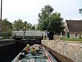
Just after Roydon Lock, the railway crosses the navigation on a low bridge. Roydon railway station is very close to the waterway. The navigation then enters the Lee Valley Regional Park. It winds its way between old gravel pits that are now filled with water. Just above Brick Lock, you'll see the three-story Roydon mill building. At the lock, the lock-keeper's cottage, built in 1830, still stands. It has a special plaque that says "G.D. 1830," celebrating Sir George Duckett, who helped build the waterway. The very last lock is Lower Lock. After this, the Stort Navigation joins the Lee Navigation.
Images for kids
-
Sheering Mill lock

