
Strachur Bay facts for kids
Quick facts for kids Strachur Bay |
|
|---|---|

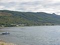
Looking down the slopes of Meall Reamhar towards Strachur Bay
|
|

Strachur Bay
Location in Argyll and Bute
|
|
| Location | Strachur |
| Coordinates | 56°10′03″N 5°05′05″W / 56.1674°N 5.08479452°W |
| Type | sea loch bay |
| River sources | Eas Dubh |
| Settlements | Dunkeld |
Strachur Bay is a beautiful bay located on the eastern side of Loch Fyne. Loch Fyne is the longest sea loch in Scotland. The bay is found in Argyll and Bute, on Scotland's west coast. Strachur Bay is a safe place for small boats to anchor. It is especially good when winds blow from the northeast or southeast.
Contents
Life Around Strachur Bay
The village of Strachur is located right at the top of the bay. This area is a popular spot for tourists visiting the Cowal peninsula. Just north along the coast of Loch Fyne is the small village of St Catherines.
Strachur is also a starting point for scenic drives. One road, the A886, takes you to Colintraive. From there, you can even take a ferry to the Isle of Bute. Another road, the A815, continues past Strachur. It goes through beautiful areas like Glenbranter and along the coast of Loch Eck. This road eventually leads south to towns like Dunoon.
Strachur House and a Famous Visitor
Overlooking the northern part of Strachur Bay is Strachur House. This historic house once hosted a very famous guest. In September 1848, the brilliant composer Frédéric Chopin stayed there for a week. He was invited by Lord and Lady Murray. Lady Murray had been one of his first music students in London.
The Landscape of Strachur Bay
Strachur Bay is surrounded by interesting hills and forests. To the south, you can see the hill called Cruach nan Capull, which is 481 meters (about 1,578 feet) tall.
Behind the bay, to the south and southeast, is Meall Reamhar. This hill is 293 meters (about 961 feet) high and is covered in thick forest. This forest is part of what used to be the larger Glenbranter Forest. Meall Reamhar rises to a slightly higher peak called An Càrr, which is 335 meters (about 1,099 feet) tall. Further back, you'll find Sidhean Sluaigh at 436 meters (about 1,430 feet), with the tallest peak, Cruach nan Capull, behind it.
A valley cut by the Glean Dubh separates Cruach nan Capull from another hill also named Meall Reamharr, which is 433 meters (about 1,421 feet) high. To the east of Meall Reamharr is the village of Glenbranter and the beautiful valley of Glenbranter.
Images for kids
-
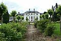
Strachur House
-
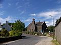
Strachur Church of Scotland
-
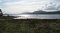
Strachur Bay
-
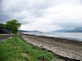
Loch Fyne from Strachur Bay
-
Strachur Bay on Loch Fyne


