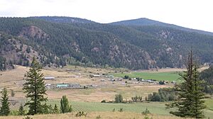
Stswecem'c Xgat'tem First Nation facts for kids
The Stswecem'c Xgat'tem First Nation is a group of Indigenous people in British Columbia, Canada. They are part of the Secwépemc (Shuswap) Nation. This nation was formed when two groups, the Canoe Creek Band and the Dog Creek Band, joined together. They live in the beautiful Fraser Canyon-Cariboo region. The Stswecem'c Xgat'tem First Nation is also a member of the Northern Shuswap Tribal Council.
Their traditional lands stretch across the Fraser River. These lands include areas around Dog Creek and Canoe Creek. This region is west of 100 Mile House and south of Williams Lake.
The Stswecem'c Xgat'tem First Nation has never signed a treaty giving up their land. They are working with the governments of Canada and British Columbia to create a final agreement. This agreement will help settle land claims. In 2018, they signed an "Agreement in Principle." When a final agreement is reached, their current reserve lands are expected to become part of larger settlement lands. This will give the Stswecem'c Xgat'tem First Nation more control over their traditional territory.
Understanding Indian Reserves
Indian Reserves are specific areas of land set aside for First Nations people. In the 1860s, the government of British Columbia created these reserves. However, the Stswecem'c Xgat'tem First Nation has always said that these reserves were created without their full agreement. They have never given up their claim to their larger traditional territory.
Once a final agreement is signed, these reserves are expected to become part of the larger settlement lands. This means the Stswecem'c Xgat'tem First Nation will have more control over their lands.
- Canoe Creek Indian Reserve No. 1: This reserve is 37.2 hectares (about 92 acres) on Canoe Creek. It is about 5 miles northeast of where Canoe Creek meets the Fraser River.
- Canoe Creek Indian Reserve No. 2: This is a larger reserve, 1804.9 hectares (about 4,460 acres), also on Canoe Creek. It is about 6 miles east of where Canoe Creek meets the Fraser River.
- Canoe Creek Indian Reserve No. 3: This reserve is 2804.9 hectares (about 6,931 acres) along the Fraser River. It is 4 miles south of where Dog Creek meets the Fraser River.
- Copper Johnny Meadow Indian Reserve No. 8: This reserve is 32.4 hectares (about 80 acres). It is located 16 miles northwest of the 70 Mile House Post Office.
- Dog Creek Indian Reserve No. 1: This reserve is 144.7 hectares (about 357 acres) on Dog Creek. It is 4 miles east of where Dog Creek meets the Fraser River.
- Dog Creek Indian Reserve No. 2: This reserve is 218.5 hectares (about 540 acres) on Dog Creek. It is 8 miles east of where Dog Creek meets the Fraser River.
- Dog Creek Indian Reserve No. 3: This smaller reserve is 8.1 hectares (about 20 acres) on Dog Creek. It is 10 miles east of where Dog Creek meets the Fraser River.
- Dog Creek Indian Reserve No. 4: This reserve is 183.7 hectares (about 454 acres) on the left bank of the Fraser River. It is north of the mouth of Dog Creek.
- Fish Lake Indian Reserve No. 5: This reserve is 40.9 hectares (about 101 acres). It is on the west end of Canoe Lake, at the start of Canoe Creek.
- Spilmouse Indian Reserve No. 4: This reserve is 161.8 hectares (about 400 acres) on Canoe Creek. It is 1 mile north of Canoe Creek Indian Reserve No. 2.
- Tinmusket Indian Reserve No. 5A: This reserve is 16.2 hectares (about 40 acres). It is 7 miles northwest of the 70 Mile House BC Rail station.
- Toby Lake Indian Reserve No. 6: This reserve is 129.5 hectares (about 320 acres) on Toby Lake. It is 3 miles north of Alberta Lake and 11 miles northwest of 70 Mile House.
Population Information
The population of the Stswecem'c Xgat'tem First Nation has changed over the years. In 1996, there were 180 people. By 2001, the population had grown to 265 people.
Notable People
- Adam Beach: A well-known actor and writer.
See also
 | James B. Knighten |
 | Azellia White |
 | Willa Brown |


