
Sudbrook (stream) facts for kids
Quick facts for kids Sudbrook |
|
|---|---|

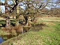
Sudbrook, near Ham Gate and pond, Richmond Park
|
|

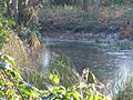
Sudbrook outfall to the Thames at Petersham, London.
|
|
| Country | United Kingdom |
| Physical characteristics | |
| Main source | Dann's Pond, Richmond Park, Greater London 51°25′40.74″N 0°16′47.64″W / 51.4279833°N 0.2799000°W |
| River mouth | Petersham Meadows, River Thames 4.5 metres Above Ordnance Datum 51°26′55.34″N 0°18′20.88″W / 51.4487056°N 0.3058000°W |
| Length | 3.8 km (2.4 mi) |
| Basin features | |
| Tributaries |
|
The Sudbrook and its smaller helper, the Latchmere stream, are two streams that flow north. They help drain the northern part of Kingston upon Thames and the eastern edge of Ham. The Sudbrook starts in a narrow valley in the southern part of Richmond Park. Both streams eventually flow into the River Thames.
What is the Sudbrook?

The Sudbrook gets its name from 'South brook'. It starts from a small pond near Dann's Pond in the very south of Richmond Park. The stream flows generally north-northwest towards Ham Gate.
As it flows, the Sudbrook creates a small valley called Ham Dip. Along its path, the stream has been dammed in two spots. This created two larger ponds: 'Ham Dip Pond' and 'Ham Gate Pond'. These ponds were first shown on maps in 1861 and 1754. They were originally made to provide water for deer in the park. Both ponds were cleaned and restored in 2013. The Sudbrook drains the western side of a hill. The eastern side of this hill drains into the Beverley Brook, and the southern side drains into the Hogsmill River.

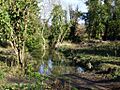
The Latchmere stream joins the Sudbrook just after Ham Gate Pond. From there, the Sudbrook flows into Sudbrook Park, Petersham. For the rest of its journey, the stream flows through a culvert. A culvert is like a large pipe or tunnel that carries water underground. The Sudbrook then empties into the River Thames. Its exit point is protected by a special valve that stops river water from flowing back into the culvert when the tide is high.
Before it was put into a culvert, the Sudbrook used to flow next to the A307 road in Petersham. People used to cross it at Sudbrook Lane using a ford, which is a shallow place where you can walk or drive across a river. In the late 1970s, part of the culvert collapsed. This event was known as the Petersham Hole. It caused major traffic problems for more than a year.
Exploring the Latchmere Stream


The name Latchmere might come from old words meaning 'lazy' or 'slow-moving lake'. It could also be linked to 'lammas land', which was a type of shared land often connected to churches.
The Latchmere stream, also called Latchmere brook, began as drainage ditches. These ditches were in the Canbury area, northeast of Kingston railway station. Historically, this area was low and would flood during certain seasons. Today, flooding is less common because some drains now send water directly to the Thames or Hogsmill River. Also, many homes have 'soakaways' that help rainwater sink into the ground.
Some surface water still flows north-east and then north. Water from Richmond Park also seeps into a tiny pond called Gallows Pond, which is on a hillside. For about 305 meters, the southern part of Kings Road forms a sharp dip on the south-west side of Richmond Park.
The lower part of the Latchmere stream runs along the south side of the eastern part of Ham Common. It is about 50 meters west of Ham Gate of Richmond Park. Here, it joins the Sudbrook just below Ham Gate Pond. Together, these streams flow along the western edge of Richmond Park, next to Ham Common.
From Roman times to the Saxon period and later, the northern part of Kingston town center had many small 'island fields'. These were formed by a branch of the Hogsmill River and a drainage channel connected to the Latchmere stream.
As Kingston grew in the early 1800s, people in Canbury started using their ditches as open sewers. This caused bad smells and health risks. In 1866, the Kingston Board of Guardians reported, The stench from this ditch, which is an open one, is always bad, but in summer it is beyond words to describe. These open sewers led to serious health problems. By the early 1890s, Kingston had a proper sewage system that sent waste to the Thames. However, the slow-moving brook, which some people still used for water, continued to cause some cases of serious illness in babies and diphtheria. By the early 1900s, people were widely warned not to drink from streams, ditches, or shallow wells in towns.
As more houses were built on what used to be farmland, the Latchmere stream was put into a culvert. However, its original path can still be seen during very heavy rain. The streets in this area are now managed to prevent flooding from rainwater.
Images for kids
-
Sudbrook, near Ham Gate and pond, Richmond Park
-
Dann's Pond, Richmond Park
-
Ham Gate Pond, fed by Sudbrook
-
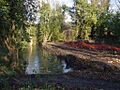
Latchmere stream outfall pond outside Ham Gate, Richmond Park, December 2012
-
Latchmere stream outfall pond in February 2014
