Superior Bottom, West Virginia facts for kids
Quick facts for kids
Superior Bottom, West Virginia
|
|
|---|---|

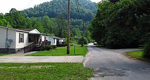
A road in Superior Bottom
|
|
| Country | United States |
| State | West Virginia |
| County | Logan |
| Elevation | 840 ft (260 m) |
| Time zone | UTC-5 (Eastern (EST)) |
| • Summer (DST) | UTC-4 (EDT) |
| Area code(s) | 304 & 681 |
| GNIS feature ID | 1555759 |
Superior Bottom is a small place in Logan County, West Virginia, United States. It's known as an unincorporated community. This means it's a group of homes and businesses that isn't officially a city or town with its own local government.
Contents
What is Superior Bottom?
Superior Bottom is located in the beautiful state of West Virginia. It sits along West Virginia Route 44, which is a main road in the area. It's also found near a waterway called Island Creek.
Where is it Located?
Superior Bottom is about 7 miles (or 11 kilometers) south of a larger town called Logan. This makes it part of the wider Logan County area. The community is nestled in a valley, which is common in the hilly landscape of West Virginia.
What is an Unincorporated Community?
An unincorporated community like Superior Bottom doesn't have its own mayor or city council. Instead, it's usually governed by the county it's in. For Superior Bottom, that's Logan County. People living here still get services like roads and police from the county government.
Geography and Surroundings
Superior Bottom is part of the Appalachian Mountains region. This area is famous for its green hills and many streams. The community's location along Island Creek means it's close to nature.
Natural Features
The elevation of Superior Bottom is about 840 feet (256 meters) above sea level. This elevation is typical for communities in the valleys of West Virginia. The surrounding landscape is full of trees and wildlife.
 | Madam C. J. Walker |
 | Janet Emerson Bashen |
 | Annie Turnbo Malone |
 | Maggie L. Walker |


