Island Creek (West Virginia) facts for kids
Quick facts for kids Island Creek |
|
|---|---|

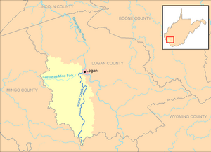
Island Creek and its watershed in Logan County, West Virginia
|
|
| Country | United States |
| State | West Virginia |
| County | Logan |
| Physical characteristics | |
| Main source | Horsepen Mountain, near Mountain View 1,837 ft (560 m) 37°38′44″N 81°59′36″W / 37.6456631°N 81.9934561°W |
| River mouth | Guyandotte River Logan 663 ft (202 m) 37°50′55″N 81°59′49″W / 37.8487146°N 81.9970693°W |
| Length | 18.1 mi (29.1 km) |
| Basin features | |
| Basin size | 105 sq mi (270 km2) |
| Tributaries |
|
Island Creek is a small but important river in southern West Virginia, United States. It is about 18 miles (29 kilometers) long. This creek is a tributary, which means it is a smaller river that flows into a larger one. Island Creek flows into the Guyandotte River.
Island Creek is part of a much bigger river system. Its waters eventually join the Ohio River and then the mighty Mississippi River. This means Island Creek is part of the huge watershed of the Mississippi River. It drains an area of about 105 square miles (272 square kilometers). This area is mostly rural and sits on a part of the Allegheny Plateau that was not covered by glaciers long ago. The entire path of Island Creek and its drainage area are found within Logan County.
Island Creek: A West Virginia River
Island Creek starts high up on Horsepen Mountain. This mountain is in the very southern part of Logan County. The creek begins near a community called Mountain View. From there, it flows generally north.
Where Does Island Creek Flow?
As Island Creek travels north, it passes through many small communities. These include places like Crystal Block, Sarah Ann, and Omar. It also flows past Switzer, Monaville, and Mount Gay.
The creek's journey ends in the city of Logan. Here, Island Creek flows into the Guyandotte River. It joins the Guyandotte River right across from a place called Hatfield Island. For most of its path, West Virginia Route 44 runs right alongside Island Creek.
Understanding the Island Creek Watershed
A watershed is an area of land where all the water drains into a common point, like a river or a lake. The Island Creek watershed is mostly covered by forests. About 94% of the land in this area is forested. Most of these trees are deciduous, meaning they lose their leaves in the fall.
The biggest tributary of Island Creek is the Copperas Mine Fork. This smaller creek is very important because it drains a large part of Island Creek's watershed. Copperas Mine Fork contributes about 43% of the water to Island Creek. It flows into Island Creek near the community of Mount Gay.
 | Audre Lorde |
 | John Berry Meachum |
 | Ferdinand Lee Barnett |

