Copperas Mine Fork facts for kids
Quick facts for kids Copperas Mine Fork |
|
|---|---|

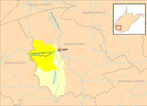
Copperas Mine Fork and its watershed, highlighted within the larger Island Creek watershed in Logan County, West Virginia.
|
|
| Country | United States |
| State | West Virginia |
| County | Logan |
| Physical characteristics | |
| Main source | western Logan County 1,413 ft (431 m) 37°49′48″N 82°07′29″W / 37.83000°N 82.12472°W |
| River mouth | Island Creek Mount Gay 667 ft (203 m) 37°50′30.1″N 82°00′30.1″W / 37.841694°N 82.008361°W |
| Length | 9.3 mi (15.0 km) |
| Basin features | |
| Basin size | 45.4 sq mi (118 km2) |
The Copperas Mine Fork is a small river, also called a tributary, in southern West Virginia, United States. It flows into a larger river called Island Creek. The Copperas Mine Fork is about 9.3 miles (15.0 km) long.
This river is part of a much bigger watershed that eventually leads to the Mississippi River. A watershed is an area of land where all the water drains into a single river or body of water. The Copperas Mine Fork watershed covers about 45.4 square miles (118 km2).
What is Copperas Mine Fork?
The Copperas Mine Fork is an important part of the local water system in Logan County. It helps carry water from the land into larger rivers. This area is known for its hilly landscape and coal mining history.
The river flows through a rural part of the Allegheny Plateau. This plateau is a large, high area of land. The Copperas Mine Fork helps shape the land as it flows, carrying water and sediment.
Where Does it Start and End?
The Copperas Mine Fork begins in the western part of Logan County. This is near the border with Mingo County. It starts high up, at an elevation of about 1,413 ft (431 m).
From its source, the river flows generally towards the east. It passes through several small communities. These include Sulphur Springs, Beebe, Holden, and Cora.
The Copperas Mine Fork finally ends in a place called Mount Gay. Here, it joins Island Creek from the west. This meeting point is about 1 mile (1.6 km) west of the city of Logan. The elevation at its mouth is about 667 ft (203 m).
Its Journey to the Ocean
Even though Copperas Mine Fork is a small river, its water travels a long way. When it flows into Island Creek, its journey is just beginning.
Island Creek then flows into the Guyandotte River. The Guyandotte River then joins the mighty Ohio River. Finally, the Ohio River flows into the huge Mississippi River. All this water eventually reaches the Gulf of Mexico, which is part of the Atlantic Ocean. So, a drop of water from Copperas Mine Fork could travel thousands of miles to the sea!
 | Madam C. J. Walker |
 | Janet Emerson Bashen |
 | Annie Turnbo Malone |
 | Maggie L. Walker |

