
Sơn La province facts for kids
Quick facts for kids
Sơn La province
Tỉnh Sơn La
|
|
|---|---|
   .jpg)   .jpg)  Mường La Mountain • Sơn La Dam • Dải Yếm Waterfall • Bản Phúc Mountain • Mộc Châu Mountain • Quỳnh Nhai Mountain pass • Pha Đin Mountain pass • Sơn La City
|
|

Location of Sơn La within Vietnam
|
|
| Country | |
| Region | Northwest |
| Capital | Sơn La |
| Subdivision | 1 city, 11 rural districts |
| Government | |
| • Type | Province |
| • Body | Sơn La Provincial People's Council |
| Area | |
| • Province | 14,123.5 km2 (5,453.1 sq mi) |
| Population
(2021)
|
|
| • Province | 1,255,826 |
| • Density | 88.9175/km2 (230.2952/sq mi) |
| • Urban | 202,589 |
| Ethnic groups | |
| • Thái | 53.61% |
| • Vietnamese | 16.26% |
| • Mông | 16.06% |
| • Mường | 6.78% |
| • Xinh Mun | 2.17% |
| • Others | 5.12% |
| Time zone | UTC+7 (ICT) |
| Area codes | 212 |
| ISO 3166 code | VN-05 |
Sơn La is a beautiful province in the Northwest part of Vietnam. It shares a border with Laos to the south. This province is quite large, covering about 14,123 square kilometers.
In 2019, more than 1.2 million people lived in Sơn La. Many different groups of people call this province home, including the Black and White Tai ethnic groups.
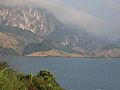
One of the most important places here is the Sơn La Dam. It's the largest hydroelectric power station in all of Southeast Asia! This dam helps create electricity for many people.
Contents
About Sơn La Province
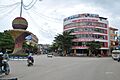
Sơn La is known for its amazing mountains and green landscapes. It's a place where you can see stunning views and learn about different cultures. The province's capital city is also called Sơn La.
How Sơn La is Organized
Sơn La province is divided into smaller areas to help manage everything. It has one main city and 11 rural districts. These districts are further split into even smaller areas called communes. In total, there are 12 main parts and 204 smaller commune-level areas.
- Sơn La City: This is the capital and the biggest city in the province.
- Districts: The other 11 areas are districts, which are mostly rural. Some of these include Bắc Yên District, Mai Sơn District, Mộc Châu District, and Mường La District.
Who Leads Sơn La?
The province is run by a group of leaders. The two main leaders are the Chairman of the People's Council, Nguyễn Thái Hưng, and the Chairman of the People's Committee, Hoàng Quốc Khánh. They work to make sure the province runs smoothly and serves its people.
What to See and Do
Sơn La has many interesting places to visit and things to experience.
Sơn La Dam
The Sơn La Dam is a huge structure that creates a large lake. It's not just important for power; it's also an impressive sight to see.
Mộc Châu Plateau
The Mộc Châu plateau is a famous area known for its beautiful tea plantations and dairy farms. It's a popular spot for tourists because of its cool climate and lovely scenery. You can see endless green hills here.
Other Interesting Places
- Nà Sản Airport: This airport helps people travel to and from Sơn La.
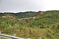
- Pha Din Pass: This is a famous mountain pass with winding roads and incredible views. It's a thrilling drive through the mountains.
- Dải Yếm Waterfall: A beautiful waterfall that is a great place to visit and enjoy nature.
People and Culture
Sơn La is home to many different ethnic groups. The Thái people make up the largest group, followed by the Vietnamese and Mông people. Other groups like the Mường and Xinh Mun also live here. Each group has its own unique traditions, languages, and festivals, making Sơn La a very diverse place.
Images for kids
-
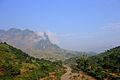
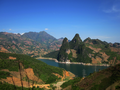
Mường La Mountain
-
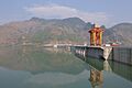
Sơn La Dam
-
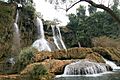
Dải Yếm Waterfall
-
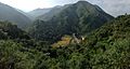
Bản Phúc Mountain
-
Mộc Châu Mountain
-
Quỳnh Nhai Mountain pass
-
Pha Đin Mountain pass
-
Sơn La City
See also
 In Spanish: Provincia de Sơn La para niños
- Nà Sản Airport
- Mộc Châu plateau
