Térraba River facts for kids
Quick facts for kids Térraba River |
|
|---|---|

Térraba River
|
|
|
Location of mouth
|
|
| Other name(s) | Río Térraba |
| Country | Costa Rica |
| Physical characteristics | |
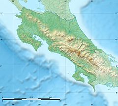
| River mouth | Pacific Ocean 9°01′56″N 83°37′36″W / 9.032256°N 83.626742°W |
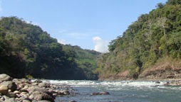
The Térraba River is the biggest river in Costa Rica, a beautiful country in Central America. It flows through the southern part of Costa Rica, in a region called Brunca. This river is also known by its local name, Río Grande de Térraba, which means "Great River of Térraba" in Spanish.
The native people of the area, the indigenous Boruca tribe, call the river Diquís. This name also means "great river" in their language.
Contents
The Térraba River: Costa Rica's Giant
The Térraba River is about 160 kilometers (100 miles) long. Its basin, which is the area of land where all the water flows into the river, covers 5,085 square kilometers (1,963 square miles). This huge area is about ten percent of the entire country of Costa Rica!
The Térraba River is formed when two other rivers, the Río General and the Río Coto Brus, join together. This meeting point is called a confluence.
Life Around the River
The land around the Térraba River is very important for farming. Many pineapple plantations are found in the river's basin. These farms cover a large area, about 10,815 hectares (26,725 acres). This makes up 21 percent of all the pineapples grown in Costa Rica.
The mouth of the Térraba River, where it meets the ocean, has many mangrove swamps. These are special forests that grow in salty water. In these swamps, people collect small shellfish called mangrove cockles. They are known locally as piangua and are an important food source. The two main types found here are Anadara tuberculosa and Anadara similis.
Traveling Along the River
A major road called the Interamerican Highway follows part of the Térraba River's path. There is a large bridge that helps cars cross the river.
Several towns and villages are located along the river's banks. These include Palmar Norte, Palmar Sur, and Ciudad Cortés.
The Térraba River eventually flows into the Pacific Ocean. It reaches the ocean through six different openings, or mouths. These mouths have names like Mala, Brava, Chica, Zacate, Guarumal, and Sierpe.
Protecting the River
Near where the river meets the ocean, there is a special protected area. It's called Humedal Nacional Térraba-Sierpe, or the Térraba-Sierpe National Wetlands. This area is important for protecting the mangroves and the many animals that live there. It is a nationally protected wetland.
Years ago, there was a plan to build a large power plant on the river. This was called the El Diquís Hydroelectric Project. It would have used the river's water to create renewable energy, which is good for the environment. However, the project was cancelled because it would have covered a very large area, about 7,000 hectares (17,300 acres). This would have meant that about 1,500 people would need to move from their homes.
See also
 In Spanish: Río Térraba para niños
 | Jessica Watkins |
 | Robert Henry Lawrence Jr. |
 | Mae Jemison |
 | Sian Proctor |
 | Guion Bluford |


