Tūranganui-a-Kiwa / Poverty Bay facts for kids
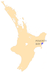
Poverty Bay (in Māori: Tūranganui-a-Kiwa) is a large bay on the east coast of New Zealand's North Island. It is located just north of Hawke Bay. The bay stretches for about 10 kilometers (6 miles) from Young Nick's Head in the southwest to Tuaheni Point in the northeast.
The city of Gisborne sits on the northern side of the bay. A smaller town called Muriwai is at the southern end. Sometimes, people use "Poverty Bay" to talk about the whole area around Gisborne. This area is home to several Māori iwi (tribes), including Te Aitanga-a-Māhaki, Rongowhakaata, and Ngāi Tāmanuhiri.
Contents
A Look Back: History of Poverty Bay
The first European known to visit New Zealand was Captain James Cook. He landed here on October 7, 1769, aboard his ship, the HMS Endeavour. At that time, the bay was known as Teoneroa.
During this first meeting, there was a conflict with the local Māori people, and a person named Te Maro died. Captain Cook was able to get some plants that helped prevent scurvy (a disease caused by lack of vitamin C). However, he couldn't get many of the supplies he and his crew needed. Because of this, he named the bay Poverty Bay. Before the conflict, Cook had thought about naming it Endeavour Bay to remember where his ship first landed in New Zealand.
In February 2019, the bay's name was officially made Tūranganui-a-Kiwa / Poverty Bay by the New Zealand Geographic Board.
During the 1800s, some stations for hunting whales were set up in the bay.
Te Kooti's Escape and Conflict
In 1868, Te Kooti, a Māori leader, and his followers were held on the Chatham Islands. Te Kooti and about 300 warriors managed to take over a ship called the Rifleman. They escaped with their families from the Chatham Islands and sailed to Poverty Bay. They landed at Whareongaonga Bay, near Young Nick's Head.
From there, Te Kooti led a guerilla war for several years. He fought against the armed police and Māori who supported the government. He also carried out attacks on settlers and Māori villages that were against him. On November 10, 1868, Te Kooti and his followers attacked the town of Matawhero, which is near Gisborne. During this attack, about 54 people died, including both local Māori and European settlers.
The Land and Its Riches: Geography of Poverty Bay
The Waipaoa River flows into Poverty Bay. This river's area is very large, covering about 2,205 square kilometers (851 square miles). This means that even small storms can bring a lot of soil and tiny bits of rock (sediments) into the bay.
What the Bay's Sediments Tell Us
The sediments at the bottom of Poverty Bay are very important. They act like a record book, showing how the area has changed over time. These sediments can tell us about:
- Changes caused by weather patterns like ENSO.
- How the land changed when Polynesians first settled in New Zealand and cleared forests.
- More changes when Europeans arrived and cleared even more forests.
- The effects of the Taupo eruption, a huge volcanic event.
A Fertile Land: Farming and Produce
Poverty Bay is one of the most fertile places in New Zealand. It gets a lot of sunshine and has rich, fertile soil that the river brings down. This makes it a great place for farming. The area is famous for its:
- Chardonnay grapes (used to make wine).
- Various fruits and vegetables.
- Avocados.
 | Jackie Robinson |
 | Jack Johnson |
 | Althea Gibson |
 | Arthur Ashe |
 | Muhammad Ali |


