
Taupo Volcano facts for kids

Lake Taupo is in the middle of New Zealand's North Island. It's actually the huge bowl, or caldera, left behind by a giant supervolcano called the Taupo Volcano. This volcano has had two of the most powerful eruptions in the world in recent times.
The Taupo Volcano is part of the Taupo Volcanic Zone. This is an active area that stretches from Ruapehu in the south, through the Taupo and Rotorua areas, all the way to White Island.
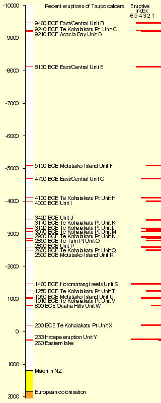
Taupo started erupting about 300,000 years ago. The two biggest eruptions that shaped the land we see today were the Oruanui eruption and the Hatepe eruption. The Oruanui eruption happened about 26,500 years ago. The Hatepe eruption happened around 232 CE. Many other eruptions have occurred, usually one big one every thousand years or so.
The volcano has been quiet for a while, about 1,800 years. But it has been inactive for even longer periods in the past. Other volcanoes in the Taupo Volcanic Zone have erupted more recently. For example, Mount Tarawera had a powerful eruption in 1886. Whakaari/White Island also erupted in December 2019.
Contents
What are Rhyolitic Eruptions?
The Taupo Volcano erupts rhyolite. This is a thick type of molten rock, or magma. It has a lot of silica in it.
If the magma doesn't have much gas, it usually just forms a dome of lava. But if it mixes with gas or steam, rhyolite eruptions can be super powerful. The magma turns into bubbly rock called pumice and ash. This is then shot out with incredible force.
If the volcano creates a steady cloud high in the sky, the pumice and ash get blown sideways. They eventually fall to the ground, covering the landscape like snow.
Sometimes, the material thrown out cools too fast. It becomes heavier than the air. Then, it can't rise high. Instead, it suddenly falls back down, creating a pyroclastic flow. This flow hits the ground like a waterfall and spreads across the land at amazing speeds. When the pumice and ash settle, they are hot enough to stick together. They form a rock called ignimbrite. Pyroclastic flows can travel hundreds of kilometers per hour.
Taupo's Earlier Eruptions
Some very old ignimbrite eruptions happened further north than Taupo. A couple of these were huge. About 1.25 million and 1 million years ago, eruptions were so big they covered the North Island from Auckland to Napier.
Taupo has been active for 300,000 years. But explosive eruptions became more common starting about 65,000 years ago.
The Oruanui Eruption

The Oruanui eruption of the Taupo Volcano was the biggest known eruption in the last 70,000 years. It had a Volcanic Explosivity Index of 8, which is extremely powerful. It happened around 26,500 years ago.
This eruption produced a massive amount of material. It created about 430 cubic kilometers of ash and pumice that fell from the sky. It also made 320 cubic kilometers of pyroclastic flow deposits, mostly ignimbrite. Plus, 420 cubic kilometers of material stayed inside the volcano's crater. This is like 530 cubic kilometers of magma.
Today's Lake Taupo partly fills the giant caldera created by this eruption.
Ash from the eruption covered most of the central North Island. In some places, the ignimbrite was up to 200 meters deep. Most of New Zealand was covered in ash. Even the Chatham Islands, 1000 kilometers away, got an 18-centimeter layer of ash. This eruption also changed the landscape. It made the Waikato River move from the Hauraki Plains to its current path to the Tasman Sea.
The Hatepe Eruption

The Taupo eruption, also known as the Hatepe eruption, was the most recent major eruption of the Taupo Volcano. It happened about 1,800 years ago. It was the most powerful eruption in the world in the last 5,000 years.
How the Eruption Happened
The eruption happened in several steps:
- A small eruption happened under the old Lake Taupo.
- Activity greatly increased, and a high column of ash shot from a second opening. Pumice fell over a large area.
- Water got into the first opening and mixed with the magma. This caused white, ash-rich pumice to fall.
- A new opening formed. It produced dark ash and obsidian-rich rock.
- A much bigger eruption followed. It spread pumice over a huge area and created a small ignimbrite deposit.
- The most destructive part of the eruption then occurred. Part of the volcano's opening collapsed. This released about 30 cubic kilometers of material. It formed a fast-moving pyroclastic flow that traveled at 600 to 900 kilometers per hour.
- Years later, rhyolitic lava domes pushed out. These formed the Horomatangi reefs and the Waitahanui bank.
The main pyroclastic flow destroyed the area around it. It climbed over 1500 meters to go over the nearby Kaimanawa Ranges and Mount Tongariro. It covered the land within 80 kilometers with ignimbrite, from Rotorua to Waiouru. Only Ruapehu was tall enough to stop the flow.
The pyroclastic flow was so strong that in some places it wore away more material from the ground than it left behind. Valleys were filled with ignimbrite, making the land flatter.
All plants in the area were flattened. Loose pumice and ash created mudflows, called lahars, down all the main rivers.
The eruption also made the lake much bigger. The lake had formed after the even larger Oruanui eruption. The old outlet was blocked, raising the lake 35 meters above its current level. Then, it burst out in a huge flood. The flood flowed for over a week at about 200 times the Waikato River's normal speed.
When Did the Taupo Eruption Happen?
Many dates have been suggested for the Taupo eruption. One date, 181 CE, came from studying ice cores in Greenland and Antarctica. However, a more recent study in 2011 used a method called 14C wiggle-matching. This study found the date to be 232 ± 5 CE.
There were no people living in New Zealand at this time. The closest humans would have been in Australia, more than 2000 kilometers to the west.
See also
 In Spanish: Volcán Taupo para niños
