
1886 eruption of Mount Tarawera facts for kids
Quick facts for kids Eruption of Mount Tarawera |
|
|---|---|

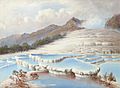
Mount Tarawera in Eruption by Charles Blomfield
|
|
| Volcano | Mount Tarawera |
| Type | Plinian, Peléan |
| Location | North Island, New Zealand 38°13′0″S 176°31′0″E / 38.21667°S 176.51667°E |
| VEI | 5 |
| Impact | ca. 120 killed, Pink and White Terraces destroyed |
.jpg)
The 1886 eruption of Mount Tarawera happened very early on June 10, 1886. This powerful volcano is located on the North Island of New Zealand, near Rotorua. The eruption then spread towards Waimangu.
This event was the deadliest volcanic eruption in New Zealand since Europeans arrived. About 120 people lost their lives. Many towns and villages were also destroyed or completely buried under ash and mud.
The Big Eruption
Just after midnight on June 10, 1886, people in the Rotorua area felt more than 30 earthquakes. These quakes grew stronger and stronger. They also saw strange flashes of light in the sky coming from the direction of Mount Tarawera.
Around 2:00 AM, a very strong earthquake hit, followed by a loud explosion. By 2:30 AM, all three peaks of Mount Tarawera had exploded. They shot huge columns of smoke and ash thousands of meters into the sky.
The biggest part of the eruption started around 3:30 AM. Vents at Rotomahana created a fast-moving cloud of hot gas and ash. This cloud, called a pyroclastic surge, destroyed several villages within 6 kilometers (about 4 miles). The famous Pink and White Terraces seemed to be completely wiped out.
The volcano threw out about 2 cubic kilometers (0.5 cubic miles) of ash and rock. This was even more than what Mount St. Helens erupted in 1980. Many lakes around the mountain changed shape and size. Lake Rotomahana, the largest crater from the eruption, grew much bigger as it filled with water. The long crack created by the eruption stretches 17 kilometers (about 10.5 miles). It goes across the mountain, Lake Rotomahana, and through the Waimangu Volcanic Rift Valley.
People heard the eruption clearly as far away as Blenheim. The ash in the air was seen as far south as Christchurch, which is over 800 kilometers (about 500 miles) away. In Auckland, some people thought the sound and flashing sky meant Russian warships were attacking.
What Happened After
The eruption split Mount Tarawera and created the Waimangu Volcanic Rift Valley. This valley is at the southwestern end of the 17-kilometer (10.5-mile) crack made on June 10, 1886.
The beautiful Pink and White Terraces were natural wonders of New Zealand. For a long time, people thought they were totally destroyed. But in 2017, new research used an old map from 1859. This map helped scientists find possible spots where the Terraces might have been. A small part of the Pink Terraces was even found under Lake Rotomahana 125 years later.
Mount Tarawera had three main peaks that erupted one after another.
- The first peak to erupt was Wahanga, in the north.
- Next was Ruawahia, in the middle.
- The last was Tarawera, the southern peak.
The Tikitapu bush was buried under ash. The forests nearby were flattened by the powerful blasts.
The land was covered with millions of tons of volcanic ash, mud, and debris. On average, this layer was about 20 meters (65 feet) thick.
The official number of deaths was reported as 153. However, a scientist named Ron Keam did a lot of research. He found that about 108 people were killed by the eruption. The difference was mostly because of misspelled names or people being counted more than once. He estimated that the true death toll was around 120 people at most.
Many Māori villages were buried or destroyed. These included Moura, Te Koutu, Kokotaia, Piripai, Pukekiore, Otuapane, Te Tapahoro, Te Wairoa, Totarariki, and Waingongoro. Many people also lost their homes. This made it the deadliest eruption in New Zealand's history.
Some people who survived in Te Wairoa found shelter in a Māori meeting house. This special building was called Hinemihi. Later, Hinemihi was moved to England. It was set up on the grounds of Clandon Park. This was the home of the 4th Earl Onslow, who had been the governor-general of New Zealand at the time.
Te Wairoa is now a place tourists can visit. It is called "The Buried Village." Many people survived the eruption by hiding in the stronger buildings in Te Wairoa.
Images for kids
-
The White Terraces in a painting by Charles Blomfield. They were believed to be destroyed by the eruption.

