Taft, Louisiana facts for kids
Quick facts for kids
Taft
|
|
|---|---|

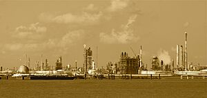
The Dow Chemical plant in Taft, photographed in 2012.
|
|
| Country | United States |
| State | Louisiana |
| Parish | St. Charles |
| Area | |
| • Total | 5.64 sq mi (14.60 km2) |
| • Land | 4.98 sq mi (12.90 km2) |
| • Water | 0.66 sq mi (1.70 km2) |
| Elevation | 7 ft (2 m) |
| Population
(2020)
|
|
| • Total | 61 |
| • Density | 12.24/sq mi (4.73/km2) |
| Time zone | UTC-6 (CST) |
| • Summer (DST) | UTC-5 (CDT) |
| Area code(s) | 985 |
| FIPS code | 22-74550 |
| GNIS feature ID | 2402911 |
Taft is a small community in St. Charles Parish, Louisiana, United States. It is located on the west side of the Mississippi River. Taft is known as a "census-designated place" (CDP). This means it's an area that the government counts for population, but it's not officially a city or town.
Contents
History of Taft
Taft is home to several large industrial facilities. These include a plant owned by The Mosaic Company that processes phosphate. There is also a Dow/Union Carbide plant. This plant makes many different organic chemicals. Part of the Waterford Nuclear Generating Station, owned by Entergy Corporation, is also located here. Most of the land in Taft is now used for heavy industry.
Early Community Life
Taft was once the original location of Our Lady of the Holy Rosary Catholic Church. This church served the communities of Taft, Killona, and Hahnville. The church building was first built in 1877. In 1963, the church moved to Hahnville. However, the cemetery in Taft is still used for burials by the church today. It is surrounded on three sides by the Dow chemical facilities.
Population Changes Over Time
When the first post office opened in Taft in 1905, about 700 people lived there. The post office stayed open until 1967. By 1977, the population had dropped significantly, with only 36 people living in Taft. This shows how much the community changed over the years.
Important Events
In December 1982, an event happened at the Union Carbide facility in Taft. This caused nearly 17,000 people to leave their homes for safety. The facility is about 30 miles from New Orleans.
Geography of Taft
Taft is located right on the Mississippi River. It is across the river from the communities of Norco and Montz.
Land and Water Area
According to the United States Census Bureau, the total area of Taft is about 5.64 square miles (14.60 square kilometers). Most of this area is land, about 4.98 square miles (12.90 square kilometers). The rest, about 0.66 square miles (1.70 square kilometers), is water.
Population Information
The population of Taft has been counted in the United States Census. A census is an official count of how many people live in an area.
Population Growth
Taft first appeared in the 2000 census. At that time, its recorded population was zero. By the 2010 census, the population had grown to 63 people. In the 2020 census, the population was 61 people.
| Historical population | |||
|---|---|---|---|
| Census | Pop. | %± | |
| 2000 | 0 | — | |
| 2010 | 63 | — | |
| 2020 | 61 | −3.2% | |
| U.S. Decennial Census 2000 2010 2020 |
|||
Racial and Ethnic Makeup
The table below shows the different racial and ethnic groups that make up the population of Taft. The census treats Hispanic/Latino as a separate ethnic group, and people of any race can be Hispanic/Latino.
| Race / Ethnicity (NH = Non-Hispanic) | Pop 2000 | Pop 2010 | Pop 2020 | % 2000 | % 2010 | % 2020 |
|---|---|---|---|---|---|---|
| White alone (NH) | 0 | 61 | 50 | 0.00% | 96.83% | 81.97% |
| Black or African American alone (NH) | 0 | 0 | 2 | 0.00% | 0.00% | 3.28% |
| Native American or Alaska Native alone (NH) | 0 | 0 | 1 | 0.00% | 0.00% | 1.64% |
| Asian alone (NH) | 0 | 0 | 0 | 0.00% | 0.00% | 0.00% |
| Pacific Islander alone (NH) | 0 | 0 | 0 | 0.00% | 0.00% | 0.00% |
| Some Other Race alone (NH) | 0 | 0 | 0 | 0.00% | 0.00% | 0.00% |
| Mixed Race or Multi-Racial (NH) | 0 | 0 | 4 | 0.00% | 0.00% | 6.56% |
| Hispanic or Latino (any race) | 0 | 2 | 4 | 0.00% | 3.17 | 6.56% |
| Total | 0 | 63 | 61 | 100.00% | 100.00% | 100.00% |
See also
 In Spanish: Taft (Luisiana) para niños
 | Audre Lorde |
 | John Berry Meachum |
 | Ferdinand Lee Barnett |


