Taft, Wisconsin facts for kids
Quick facts for kids
Taft, Wisconsin
|
|
|---|---|
 |
|

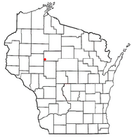
Location of Taft, Wisconsin
|
|
| Country | |
| State | |
| County | Taylor |
| Area | |
| • Total | 36.6 sq mi (94.9 km2) |
| • Land | 36.5 sq mi (94.5 km2) |
| • Water | 0.1 sq mi (0.3 km2) |
| Elevation | 1,214 ft (370 m) |
| Population
(2000)
|
|
| • Total | 361 |
| • Density | 9.9/sq mi (3.8/km2) |
| Time zone | UTC-6 (Central (CST)) |
| • Summer (DST) | UTC-5 (CDT) |
| Area code(s) | 715 & 534 |
| FIPS code | 55-78950 |
| GNIS feature ID | 1584265 |
| PLSS township | T30N R4W |
Taft is a small town in the southwestern part of Taylor County, Wisconsin, in the United States. In the year 2000, about 361 people lived there. Part of the small community called Bellinger is also located within the town of Taft.
Contents
Exploring Taft's Geography
Taft covers an area of about 36.6 square miles (94.8 square kilometers). Most of this area, 36.5 square miles (94.5 square kilometers), is land. Only a tiny part, 0.1 square miles (0.3 square kilometers), is water.
Land Features of Taft
Taft is located within the Perkinstown terminal moraine. This is a line of hills that were formed by the last glacier. When the glacier stopped moving and then melted away, it left behind these hills. You can learn more about this in the Taylor County geography section.
An esker (a long, winding ridge of sand and gravel) runs through the northwest part of Taft. You can also find "ice-walled lake plains" among the hilly areas. These are flat areas that were once lakes surrounded by ice. In some of the lower spots, you might find peat soils, which are made from decayed plant material.
Taft's Past: A Look at History
Early Surveys and Land Descriptions
In July 1847, a team from the U.S. government began surveying the area that would become Taft. They marked the boundaries of this six-mile-square area. This survey was done again in late 1848.
Then, in June 1854, another team marked all the section corners within the township. They walked through the forests and swamps, using a chain and a compass to measure everything.
After their work, the surveyor wrote down a general description of the area:
The land in this Township is generally uneven and not very fertile. It doesn't grow much vegetation because the ground is often covered with a thick, heavy moss. There are many swamps, some quite large. The trees in the swamps are mostly Tamarac. The drier land has mostly Hemlock trees. There are a few scattered groups of White Pine trees, but they are not good for lumber. Many small streams flow through the Township, starting in the swamps. There were no settlers living here at that time.
Lumber Companies and Early Settlers
By 1900, most of the land in what would become Taft was owned by large lumber companies. The Northwestern Lumber Company owned a big section in the southeast. They had even built their Stanley, Merrill and Phillips Railway a few miles into this area. Other big landowners included Chippewa Lumber and Boom Co., and Lindsay & Phelps. Only one settler, named Hobbs, was marked on the map with a homestead near Otter Creek.
By 1911, the SM&P railway had extended all the way through the town and even further. A type of road followed the path of what is now County F across the middle of the township. Another road went north along what is now Skyline Drive. Another road followed the path of modern Highway 73 south to the county line. This southeast corner had a fairly complete network of roads, though they were probably very basic.
In this corner, the Northwestern Lumber Co. had sold most of its logged land to new settlers, many of whom had Polish names. In 1911, there were many more settlers here and around Lublin than anywhere else in western Taylor County. The rest of Taft had only a few settlers at this time. Most of the land was still owned by lumber companies, with Chippewa Lumber and Boom holding the largest share.
Who Lives in Taft: Population Details
Population and Households
Based on the census from 2000, there were 361 people living in Taft. These people lived in 120 households, and 84 of these were families. The town had about 9.9 people per square mile (3.8 people per square kilometer). There were 132 houses, with an average of 3.6 houses per square mile (1.4 per square kilometer).
Most people in Taft were White (97.51%). A small number were Native American (0.55%), Asian (0.28%), or from other races (1.11%). About 0.55% were from two or more races. People who identified as Hispanic or Latino made up 1.39% of the population.
Out of the 120 households:
- 40.8% had children under 18 living with them.
- 64.2% were married couples living together.
- 2.5% had a female head of household with no husband present.
- 29.2% were not families.
- 20.8% of all households were made up of people living alone.
- 10.8% had someone living alone who was 65 years old or older.
The average household had 3.01 people, and the average family had 3.64 people.
Age and Income
The population in Taft was spread out by age:
- 34.3% were under 18 years old.
- 8.0% were from 18 to 24 years old.
- 25.5% were from 25 to 44 years old.
- 17.2% were from 45 to 64 years old.
- 15% were 65 years old or older.
The average age in Taft was 37 years. For every 100 females, there were about 109.9 males. For every 100 females aged 18 and over, there were about 119.4 males.
The average income for a household in the town was $37,500. For a family, the average income was $41,071. Males earned an average of $24,615, while females earned an average of $21,429. The per capita income (income per person) for the town was $14,447. About 5.6% of families and 8.7% of the total population lived below the poverty line. This included 10.4% of those under 18 and 13.3% of those aged 65 or older.
See also
 In Spanish: Taft (Wisconsin) para niños
 | Kyle Baker |
 | Joseph Yoakum |
 | Laura Wheeler Waring |
 | Henry Ossawa Tanner |

