
Takhar Province facts for kids
Quick facts for kids Takhār (تخار) |
|
| Province | |
| Country | Afghanistan |
|---|---|
| Capital | Taloqan |
| - coordinates | 36°42′N 69°48′E / 36.7°N 69.8°E |
| Area | 12,333 km² (4,762 sq mi) |
| Population | 886,400 (2009) |
| Timezone | UTC+4:30 |
| Main languages | Persian Uzbek Pashto |
Takhār (pronounced Tah-KHAR) is one of the 34 provinces in Afghanistan. A province is like a large region or state within a country. The main city and capital of Takhar Province is Taloqan. This province is well-known for its salt mines, which are a very important natural resource for Afghanistan.
Contents
Where is Takhar Province Located?
Takhar Province is located in the northern part of Afghanistan. It shares borders with several other provinces and even another country. To the north, it borders Tajikistan. To the east, you'll find Badakhshan Province. To the southeast, it's next to Panjshir Province. In the southwest, it borders Baghlan Province, and to the west, it's next to Kunduz Province.
 |
|
|||
| Kunduz Province | Badakhshan Province | |||
| Baghlan Province | Panjshir Province |
How Takhar Province is Organized
Like many provinces, Takhar is divided into smaller areas called districts. These districts help manage the different parts of the province. There are many districts in Takhar, each with its own local community.
Images for kids
-
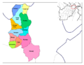
Districts of Takhar Province.
-
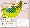
Ethnolinguistic groups in Afghanistan.


See also
 In Spanish: Provincia de Tahar para niños
