
Tambo Island facts for kids

Tambo Island
|
|

Tambo Island
Location in Spain
|
|
| Geography | |
|---|---|
| Coordinates | 42°24′42.7″N 8°42′32.6″W / 42.411861°N 8.709056°W |
| Area | 0.28 km2 (0.11 sq mi) |
| Length | 4 km (2.5 mi) |
| Highest elevation | 80 m (260 ft) |
| Administration | |
|
Spain
|
|
| Autonomous community | Galicia |
| Province | Pontevedra |
| Municipality | Poio |
Tambo Island is a small island located in the middle of the Pontevedra Bay in Spain. It is part of the Poio area, separated from the mainland by a shallow channel about 1.1 kilometers (0.7 miles) wide.
The island covers an area of 0.28 square kilometers (about 0.11 square miles). Its highest point is 80 meters (262 feet) above sea level, and its edge stretches for 4 kilometers (2.5 miles). Tambo Island has a unique shape, with a small peninsula on its southern side.
Contents
Discovering Tambo Island's Past
Tambo Island has a long and interesting history. People have lived on or visited the island for thousands of years.
Ancient Times and Early Buildings
Long ago, during the Castro culture period, people built a special settlement called a castro on the island. A castro was a fortified village, often on a hilltop. This ancient site covers the entire central part of Tambo Island.
In the 6th century, a chapel was built on the island. Later, it became a monastery and then a priory, which is a type of religious house. It was dedicated to Santa María de Gracia.
Royal Ownership and Pirate Raids
In the 12th century, Queen Urraca owned Tambo Island. She gave it to the San Juan de Poyo monastery. For many centuries, people from the nearby town of Combarro used the island. They farmed the land and held special religious events there.
However, in 1589, a famous pirate named Francis Drake attacked the chapel. He took valuable items and even threw the statue of Santa María de Gracia into the sea.
Changes in Ownership and Use
In 1846, the island stopped belonging to the monks. Later, a government minister named Eugenio Montero Ríos bought it. In the same century, a lazaretto was built on the island. This was a place where sailors arriving at the port of Marín-Pontevedra could stay in quarantine to prevent the spread of diseases.
People in Pontevedra protested because they were worried about diseases. So, the lazaretto was moved to another island. In 1889, Tambo Island became a military prison.
Military Control and Recent Changes
When the Marín Naval Military School was created in 1943, Tambo Island became a military zone. It was used as a place to store weapons and supplies. The heirs of Montero Ríos sold the island to the Navy that year.
In 2002, the Navy decided the island was no longer a strategic military location. This made people hope that Tambo Island could become part of a national park, like the Atlantic Islands of Galicia National Park. However, it remained under military control for some time.
On April 14, 2013, some people from Combarro held a symbolic "declaration of independence" for the island. This was a way to protest that the island was not being cared for after it was no longer a military base.
Finally, on March 1, 2022, Tambo Island officially stopped being a military area. This means it is now open for everyone to visit and enjoy!
Exploring Tambo Island's Features
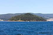
Tambo Island is shaped like an oval and looks like a pyramid. It is mostly covered with trees, especially eucalyptus.
Natural Beauty and Beaches
The island has two main beaches that can only be reached by private boat. Area da Illa is the largest and most popular beach, located on the north-eastern side. The other beach, Adreira, is smaller and found on the eastern side. It's a quiet cove with white sand, surrounded by rocks and a thick pine forest.
You can see Tambo Island from many parts of the Paseo Marítimo de Pontevedra, which is the beautiful seafront promenade in the city of Pontevedra.
Buildings on the Island
Even though no one lives on Tambo Island, there are a few buildings. These include an old naval ammunition dump, the historic chapel, and the former lazaretto.
Gallery
-

Lighthouse on the island
-
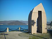
Sculpture on the harbour promenade with the island of Tambo in the background.
-
Tambo Island
-
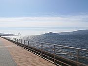
View of the island from the Pontevedra city seafront promenade
-
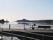
View of the island from the viewpoint of the seafront promenade of Pontevedra.


See also
 In Spanish: Isla de Tambo para niños
Related articles
- Ria de Pontevedra
