
Tanaga Island facts for kids
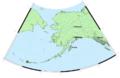
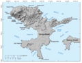
Tanaga Island is a cool island located in the western part of the Andreanof Islands. These islands are part of the larger Aleutian Islands chain in Alaska. The island is pretty big, covering about 204 square miles (528 square kilometers). This makes it the 33rd largest island in the United States that's surrounded by ocean!
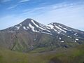
The highest point on Tanaga Island is a volcano called Mount Tanaga. It stands tall at 5,925 feet (1,806 meters). The island itself is about 43 kilometers (27 miles) long and 38 kilometers (24 miles) wide.
Tanaga Island is about 62 miles (100 kilometers) west of Adak Island, which is the closest island where people live. Tanaga Island has some amazing large waterfalls. No one lives on Tanaga Island today, but old maps show some cabins and even some Aleut villages on the eastern side of the island.
You won't find any native land mammals living on Tanaga Island.
During World War II, in July 1943, Tanaga Island was used by the Navy as an emergency landing field. A group called the Seabees (Naval Construction Battalion 45) built a runway and other important buildings. They also made a small pier, offices, storage areas, and even a radio building. The site was left in 1945, but you can still see the old control tower on maps.
Exploring Tanaga Volcano

Tanaga Island is home to an active volcano called Tanaga volcano. The last time this volcano erupted was in 1914. Before that, there were reports of eruptions in 1763-1770, 1791, and 1829. These older reports aren't super detailed, but scientists have studied the volcano's sides. They found that typical eruptions from Tanaga volcano create chunky lava flows and sometimes send ash clouds into the sky.
Eruptions can happen from the main top of the volcano or from a smaller opening on its northeast side. This smaller vent is about 5,197 feet (1,584 meters) high. Right next to Tanaga volcano is another mountain called Sajaka, which is 4,443 feet (1,354 meters) high.
Another nearby peak is Takawangha, which is 4,754 feet (1,449 meters) high. Most of Takawangha's top is covered in ice. However, it has four younger craters that have erupted ash and lava flows in the last few thousand years. Some parts of Takawangha are a bit unstable, meaning they could cause small landslides. We don't know of any eruptions from Sajaka or Takawangha in recent history. But, scientists think that some past eruptions blamed on Tanaga might have actually come from these other vents.
Earthquake Swarm in 2017
In January 2017, a series of small earthquakes happened about 6 kilometers (3.7 miles) from Takawangha. This caused the Alaska Volcano Observatory to raise the alert level for the area to YELLOW/ADVISORY. This means they were watching the volcanoes more closely.
Images for kids
-
Tanaga and East Tanaga Volcanoes on Tanaga Island
-
Location of Tanaga Island
-
Tanaga Island


See also
 In Spanish: Isla Tanaga para niños
