
Taylor Map of New York facts for kids
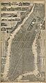
The Taylor Map is a really old and detailed map of New York City. It was made by Will L. Taylor for a company called Galt & Hoy in 1879.
This map shows the whole island of Manhattan, even though it's not perfectly to scale. Around the edges of the map, you can see old advertisements and pictures of different businesses in New York and New Jersey. When it was first sold, a copy of the map cost $10 if it came on "spring rollers," or $12.50 if it was in a fancy "black walnut or gilt case."
The original map was very big, about 188 by 107 centimetres (74 in × 42 in) (that's about 6 feet by 3.5 feet!). It was printed on four large sheets of paper. The Taylor Map was one of the first maps to try and label every road and pier. It also showed buildings in a special way, using something called a vanishing perspective, which made them look more realistic.
What You Can See on the Map


At the very bottom of the map, you can see the Brooklyn Bridge. This is interesting because the bridge wasn't even finished when the map was published!
The map shows many different places. You can find factories, like the Matthiessen and Wiechers Sugar Refining Works (which made sugar). There are also businesses, such as the famous Fifth Avenue Hotel and Brown & Pray Carriage Builders. You can even spot fun places like Manhattan Beach.
Old Advertisements
The edges of the map are covered with advertisements from the 1870s. These ads show what kinds of businesses were popular back then. Some examples include ads for "The Brewsters of 25th Street" (which might have been a carriage maker), "Dixon Crucible Co." (which made things like pencils), and the "European Salicyclic Medicine Co".
You can also see ads for fancy items like "E. Aug. Neresheimer, Importer of Diamonds" and financial services from "Robert T Hoy - Banker & Broker". There's even an ad for "WM. Rogers, with Simpson, Hall, Miller & Co", who made high-quality silver-plated dishes.
Images for kids
-
A scan of the 1879 Taylor Map of New York.

