Taylorville, Indiana facts for kids
Quick facts for kids
Taylorville, Indiana
|
|
|---|---|

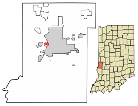
Location of Taylorville in Vigo County, Indiana.
|
|
| Country | United States |
| State | Indiana |
| County | Vigo |
| Township | Sugar Creek |
| Area | |
| • Total | 0.15 sq mi (0.39 km2) |
| • Land | 0.15 sq mi (0.39 km2) |
| • Water | 0.00 sq mi (0.00 km2) |
| Elevation | 469 ft (143 m) |
| Population
(2020)
|
|
| • Total | 38 |
| • Density | 251.66/sq mi (97.24/km2) |
| Time zone | UTC-5 (Eastern (EST)) |
| • Summer (DST) | UTC-4 (EDT) |
| ZIP code |
47885
|
| Area code(s) | 812, 930 |
| FIPS code | 18-18658 |
| GNIS feature ID | 444608 |
Taylorville, also known as Taylorsville or Dresser, is a small community in Indiana, United States. It is not a city or town with its own government. Instead, it is an "unincorporated community". This means it is a group of homes and people living together without a formal local government. Taylorville is located in Vigo County, Indiana. It is also part of the larger Terre Haute metropolitan area. The official name for the area is Taylorville. However, some people also call it Dresser.
A Look Back in Time
Taylorville was started in 1908. It was named after a local farmer called Taylor. A post office opened there in 1932. It was named Dresser. The post office closed just three years later, in 1935. People living in the area often use both names. They might say Taylorville or Dresser.
For a long time, Taylorville was known as a very close-knit community. Residents say they are independent. They also say they like to keep to themselves.
The number of people living in Taylorville has gone down recently. The community is in a floodplain. This means it is an area that can flood easily. Because of this, it is hard to get permission to build new homes there. In 2013, officials from Vigo County tried to buy properties in Taylorville. Their goal was to help residents move from homes that were at risk of flooding. However, many people in Taylorville did not want to move.
Where is Taylorville?
Taylorville is located at coordinates 39°27′45″N 87°25′25″W. It sits at an elevation of 469 feet (143 meters) above sea level. The community is very close to the Wabash River. It is nestled between the cities of Terre Haute and West Terre Haute.
People and Population
| Historical population | |||
|---|---|---|---|
| Census | Pop. | %± | |
| 2010 | 104 | — | |
| 2020 | 38 | −63.5% | |
| U.S. Decennial Census | |||
The population of Taylorville has changed over the years. In 2010, the community had 104 residents. By 2020, the population was 38 people.
 | Delilah Pierce |
 | Gordon Parks |
 | Augusta Savage |
 | Charles Ethan Porter |

