
Te Hāpua facts for kids
Quick facts for kids
Te Hāpua
|
|
|---|---|

Te Hapua Wharf
|
|
| Country | New Zealand |
| Region | Northland Region |
| District | Far North District |
| Ward | Te Hiku |
| Community | Te Hiku |
| Subdivision | North Cape |
| Electorates |
|
Te Hāpua is a small community located on the shores of the Parengarenga Harbour in Northland, New Zealand. It is known as the most northerly settlement in New Zealand. To reach Te Hāpua, you take a road that turns off State Highway 1 at Waitiki Landing. There are no shops or motels in this quiet community.
The name Te Hāpua means "the lagoon" in the Māori language, according to the New Zealand Ministry for Culture and Heritage. In 2023, about 222 people lived in the Te Hāpua area.
An important person from Te Hāpua was Matiu Rata. He was born here in 1934. Matiu Rata became a Cabinet Minister in the New Zealand government during the 1970s. He also started a political party called Mana Motuhake. He was buried in Te Hāpua.
Te Hāpua is also famous as the starting point for the 1975 Māori land march. This important march began on September 14, 1975, which was Māori Language Day. People walked from Te Hāpua all the way to Wellington to protest for Māori land rights.
The Te Reo Mihi Marae in Te Hāpua is a special meeting place for the Ngāti Kurī iwi (tribe). It includes the Te Reo Mihi meeting house, where people gather for important events and discussions.
Contents
Understanding Te Hāpua's Population
Te Hāpua is part of a statistical area that covers about 285 square kilometers. This area also includes the land north of Waitiki Landing.
The population of this area has changed over time:
- In 2006, there were 165 people.
- In 2013, the number was 144.
- In 2018, it was 141 people.
- By the 2023 New Zealand census, the population grew to 222 people. This was a big increase of 81 people since 2018!
The average age of people in Te Hāpua in 2023 was 37.6 years. About 23% of the people were under 15 years old. Most people in Te Hāpua identify as Māori, with 89.2% identifying as Māori in the 2023 census. Many people also identify as European (Pākehā). English is spoken by almost everyone, and about 33.8% of people also speak the Māori language.
Learning at Te Hāpua School
Te Hāpua School is a school for children from Year 1 to Year 8 (ages 5 to 13). It is the northernmost school in New Zealand!
The school first opened in 1896 as Parengarenga Native School. For many years, it was a special Māori school. In 1969, it became a regular school under the local education board, like other schools in New Zealand.
Te Hāpua's Weather and Climate
Te Hāpua has an oceanic climate, which means it has warm summers and mild winters. There isn't a really dry season, so it gets rain throughout the year.
The average temperature for the whole year is about 16.4 degrees Celsius (61.5°F).
- The warmest month is usually February, with an average temperature of 20.7 degrees Celsius (69.3°F).
- The coolest months are July and August, with an average temperature of 12.9 degrees Celsius (55.2°F).
Because Te Hāpua is near the ocean, the water helps to keep the temperatures from getting too hot or too cold.
Te Hāpua receives about 998 millimeters (39 inches) of rain each year. Even though it rains all year, winter usually has more rain than summer. July is often the wettest month, while January is the driest.
| Climate data for Te Hāpua, Northland, 4 m | |||||||||||||
|---|---|---|---|---|---|---|---|---|---|---|---|---|---|
| Month | Jan | Feb | Mar | Apr | May | Jun | Jul | Aug | Sep | Oct | Nov | Dec | Year |
| Mean daily maximum °C (°F) | 24.4 (75.9) |
24.9 (76.8) |
23.4 (74.1) |
21.4 (70.5) |
19.1 (66.4) |
17.1 (62.8) |
16.4 (61.5) |
16.5 (61.7) |
17.5 (63.5) |
18.7 (65.7) |
20.3 (68.5) |
22.5 (72.5) |
20.2 (68.4) |
| Daily mean °C (°F) | 20.3 (68.5) |
20.7 (69.3) |
19.4 (66.9) |
17.6 (63.7) |
15.4 (59.7) |
13.6 (56.5) |
12.9 (55.2) |
12.9 (55.2) |
13.9 (57.0) |
15.1 (59.2) |
16.7 (62.1) |
18.5 (65.3) |
16.4 (61.5) |
| Mean daily minimum °C (°F) | 16.2 (61.2) |
16.5 (61.7) |
15.4 (59.7) |
13.9 (57.0) |
11.8 (53.2) |
10.1 (50.2) |
9.4 (48.9) |
9.3 (48.7) |
10.3 (50.5) |
11.6 (52.9) |
13.1 (55.6) |
14.6 (58.3) |
12.7 (54.9) |
| Average precipitation mm (inches) | 61.0 (2.40) |
65.0 (2.56) |
75.0 (2.95) |
95.0 (3.74) |
85.0 (3.35) |
115.0 (4.53) |
116.0 (4.57) |
107.0 (4.21) |
88.0 (3.46) |
66.0 (2.60) |
63.0 (2.48) |
62.0 (2.44) |
998.0 (39.29) |
| Source: Climate-data.org | |||||||||||||
Images for kids
-
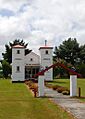
A Ratana church building in Te Hāpua.

