Tenaja Canyon Creek facts for kids
Quick facts for kids Tenaja Canyon Creek |
|
|---|---|

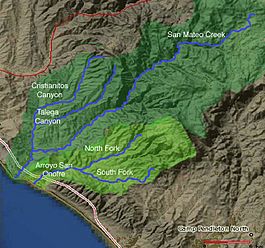
Map of San Mateo Creek and Arroyo San Onofre drainage basins. San Mateo Creek basin is in dark green.
|
|
| Other name(s) | Tenaja Canyon |
| Country | United States |
| State | California |
| Region | Riverside County |
| Physical characteristics | |
| Main source | at the head of Tenaja Canyon, at the confluence of arroyos from El Potrero del Tenaja, Redonda Mesa and Squaw Mountain highlands. 1,875 ft (572 m) 33°30′23″N 117°21′51″W / 33.50639°N 117.36417°W |
| River mouth | confluence with San Mateo Creek near Fishermans Camp 1,112 ft (339 m) 33°31′46″N 117°24′32″W / 33.52944°N 117.40889°W |
| Length | 3.5 mi (5.6 km) |
| Basin features | |
| Tributaries |
|
Tenaja Canyon Creek is a small stream, sometimes called an arroyo, located in the beautiful Cleveland National Forest in Riverside County, California. It's like a smaller helper stream because it flows into a bigger one called San Mateo Creek. This makes Tenaja Canyon Creek a "tributary" to San Mateo Creek.
The creek starts high up, about 1,875 feet (572 meters) above sea level. It begins where several smaller streams, or arroyos, meet. These smaller streams come from areas like El Potrero del Tenaja, Redonda Mesa, and Squaw Mountain.
From its starting point, Tenaja Canyon Creek flows about 3.5 miles (5.6 kilometers) towards the northwest. It winds its way down Tenaja Canyon. Its journey ends when it joins San Mateo Creek near a place called Fishermans Camp. At this point, the creek is about 1,112 feet (339 meters) above sea level.
 | Kyle Baker |
 | Joseph Yoakum |
 | Laura Wheeler Waring |
 | Henry Ossawa Tanner |

