Tennyson, Indiana facts for kids
Quick facts for kids
Tennyson, Indiana
|
|
|---|---|

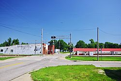
Main Street (SR 161)
|
|

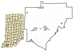
Location of Tennyson in Warrick County, Indiana.
|
|
| Country | United States |
| State | Indiana |
| County | Warrick |
| Township | Skelton |
| Area | |
| • Total | 0.23 sq mi (0.61 km2) |
| • Land | 0.23 sq mi (0.61 km2) |
| • Water | 0.00 sq mi (0.00 km2) |
| Elevation | 404 ft (123 m) |
| Population
(2020)
|
|
| • Total | 213 |
| • Density | 910.26/sq mi (351.72/km2) |
| Time zone | UTC-6 (Central (CST)) |
| • Summer (DST) | UTC-5 (CDT) |
| ZIP code |
47637
|
| Area code(s) | 812 |
| FIPS code | 18-75302 |
| GNIS feature ID | 2397694 |
| Website | https://townoftennyson.com/ |
Tennyson is a small town located in Warrick County, Indiana, in the United States. It's part of Skelton Township. In 2010, about 279 people lived there.
Contents
Discovering Tennyson's Past
Tennyson has a history that goes back to the late 1800s. A post office opened in Tennyson in 1881. The town was officially planned out around 1882. It was named after a person called George Martin Van Buren Tennyson.
Exploring Tennyson's Location
Tennyson is found in the eastern part of Warrick County. It is located northeast of Boonville, which is the main town of the county. The town's main road is Indiana State Road 161, also known as Main Street. This road runs through Tennyson from north to south.
Just east of Tennyson, you'll find Little Pigeon Creek. There's also a special state area nearby for protecting wetlands. Wetlands are important natural areas that help keep the environment healthy.
According to information from 2010, Tennyson covers a total area of about 0.23 square miles (0.61 square kilometers). All of this area is land.
Understanding Tennyson's Population
The number of people living in Tennyson has changed over the years. Here's a quick look at how the population has grown and shrunk:
| Historical population | |||
|---|---|---|---|
| Census | Pop. | %± | |
| 1900 | 302 | — | |
| 1910 | 371 | 22.8% | |
| 1920 | 386 | 4.0% | |
| 1930 | 335 | −13.2% | |
| 1940 | 293 | −12.5% | |
| 1950 | 409 | 39.6% | |
| 1960 | 312 | −23.7% | |
| 1970 | 335 | 7.4% | |
| 1980 | 331 | −1.2% | |
| 1990 | 267 | −19.3% | |
| 2000 | 290 | 8.6% | |
| 2010 | 279 | −3.8% | |
| 2020 | 213 | −23.7% | |
| U.S. Decennial Census | |||
Tennyson's Population in 2010
In 2010, a census (a count of the population) showed that 279 people lived in Tennyson. These people lived in 106 different homes, and 75 of these were families. The town had about 1,213 people per square mile.
Most of the people in Tennyson (99.3%) were White. A small number (0.4%) were African American. About 2.2% of the population identified as Hispanic or Latino.
Out of the 106 homes:
- About 36.8% had children under 18 living there.
- 47.2% were married couples living together.
- 16.0% had a female head of the household with no husband.
- 7.5% had a male head of the household with no wife.
- About 20.8% of homes had just one person living there.
- 7.6% of homes had someone living alone who was 65 or older.
The average home had about 2.63 people. The average family had about 2.89 people. The average age of people in Tennyson was 40.1 years old. About 24.4% of residents were under 18. About 12.9% were 65 or older. The town had slightly more males (50.5%) than females (49.5%).
Learning and Education in Tennyson
Tennyson has a public library. It is a part of the Boonville-Warrick County Public Library system. There is also an elementary school in Tennyson.
See also
 In Spanish: Tennyson (Indiana) para niños
 | Selma Burke |
 | Pauline Powell Burns |
 | Frederick J. Brown |
 | Robert Blackburn |

