Tesuque, New Mexico facts for kids
Quick facts for kids
Tesuque, New Mexico
|
|
|---|---|

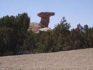
Camel Rock
|
|

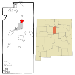
Location of Tesuque, New Mexico
|
|
| Country | United States |
| State | New Mexico |
| County | Santa Fe |
| Area | |
| • Total | 5.66 sq mi (14.65 km2) |
| • Land | 5.66 sq mi (14.65 km2) |
| • Water | 0.00 sq mi (0.00 km2) |
| Elevation | 6,929 ft (2,112 m) |
| Population
(2020)
|
|
| • Total | 1,094 |
| • Density | 193.35/sq mi (74.66/km2) |
| Time zone | UTC-7 (Mountain (MST)) |
| • Summer (DST) | UTC-6 (MDT) |
| ZIP code |
87574
|
| Area code(s) | 505 |
| FIPS code | 35-77040 |
| GNIS feature ID | 2410071 |
|
Pueblo of Tesuque
|
|
| Lua error in Module:Location_map at line 420: attempt to index field 'wikibase' (a nil value). | |
| Nearest city | Santa Fe, New Mexico |
| Area | 12.6 acres (5.1 ha) |
| Built | 1694 |
| NRHP reference No. | 73001149 |
| Significant dates | |
| Added to NRHP | July 16, 1973 |
Tesuque is a small community in Santa Fe County, New Mexico, United States. It is known as a census-designated place (CDP). This means it is a special area created by the U.S. Census Bureau for collecting population data.
Tesuque is part of the larger Santa Fe area. In 2020, about 1,094 people lived there. The community is close to, but separate from, the Tesuque Pueblo. The Pueblo is home to the Pueblo people, who are part of the Tewa Native American group. They speak the Tewa language. The Pueblo itself was recognized as a historic district in 1973.
Contents
Exploring Tesuque's Location and Landmarks
Tesuque covers an area of about 7 square miles (18 square kilometers). All of this area is land.
Camel Rock: A Natural Wonder
One of the most famous sights in Tesuque is
Camel Rock. This is a unique rock formation that looks like a camel. You can see it along U.S. Routes 84 and 285. Right across from Camel Rock, you'll find the Camel Rock Studios, which are owned by the Tesuque Pueblo.
Tesuque's Population and People
The population of Tesuque was 1,094 people in 2020. This number comes from the official 2020 United States Census.
A Look at the Community
In 2000, there were 909 people living in Tesuque. The community had 455 households. About 16.7% of these households had children under 18 living with them. The average age of people in Tesuque was 48 years old.
The people living in Tesuque come from different backgrounds. In 2000, about 35.64% of the population identified as Hispanic or Latino.
Income in Tesuque
In 2000, the average income for a household in Tesuque was about $36,029 per year. For families, the average income was higher, around $80,043 per year. The average income for each person in the community was about $52,473.
Learning and Schools in Tesuque
Tesuque is part of the Santa Fe Public Schools district. This means that students living in Tesuque attend schools within this district.
Local Schools for Students
Children in Tesuque are zoned to specific schools. These include:
- Tesuque Elementary School
- Milagro Middle School
- Santa Fe High School
Famous People from Tesuque
Many interesting people have lived in or are connected to Tesuque. Here are a few:
- Augustine Abeyta, a talented painter
- Carlene Carter, a well-known singer and songwriter
- Howie Epstein, an American musician
- Lynne and Dennis Comeau, famous shoe designers
- Dominic Frontiere, a composer
- Ali MacGraw, an actress and model
- Armistead Maupin, an author
- Cormac McCarthy, a respected author
- Anthony Michaels-Moore, an opera singer
- Eliot Porter, a nature photographer who lived in Tesuque
- Michael Tobias, an author
- Carol Jean Vigil, New Mexico's first female Native American state court judge
- Rufina Vigil, a painter
See also
 In Spanish: Tesuque (Nuevo México) para niños


