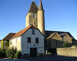
Thèze, Pyrénées-Atlantiques facts for kids
Quick facts for kids
Thèze
|
||
|---|---|---|
 |
||
|
||
| Country | France | |
| Region | Nouvelle-Aquitaine | |
| Department | Pyrénées-Atlantiques | |
| Arrondissement | Pau | |
| Canton | Terres des Luys et Coteaux du Vic-Bilh | |
| Intercommunality | Luys en Béarn | |
| Area
1
|
7.93 km2 (3.06 sq mi) | |
| Population
(Jan. 2019)
|
858 | |
| • Density | 108.20/km2 (280.2/sq mi) | |
| Time zone | UTC+01:00 (CET) | |
| • Summer (DST) | UTC+02:00 (CEST) | |
| INSEE/Postal code |
64536 /64450
|
|
| Elevation | 133–259 m (436–850 ft) (avg. 225 m or 738 ft) |
|
| 1 French Land Register data, which excludes lakes, ponds, glaciers > 1 km2 (0.386 sq mi or 247 acres) and river estuaries. | ||
Thèze is a small town, also called a commune, located in the southwestern part of France. It's found in a region known as the Pyrénées-Atlantiques département. A commune is like a local government area, similar to a township or a small municipality. A département is a larger administrative area, a bit like a county in other countries.
About Thèze
Thèze is a quiet place in France. It's known for its peaceful countryside and local community.
Where is Thèze?
Thèze is located in the southwestern part of France. It's part of the Pyrénées-Atlantiques département. This area is famous for its beautiful landscapes, including the nearby Pyrenees mountains.
People and Government
As of January 2019, about 858 people lived in Thèze. The town is led by a mayor, David Duizidou, who was elected for the term 2020–2026. The mayor and the local council help manage the town and make decisions for its residents.
Quick Facts About Thèze
- Thèze covers an area of about 7.93 square kilometers.
- The town sits at an elevation of about 225 meters above sea level. The lowest point is 133 meters, and the highest is 259 meters.
- It is part of the Luys en Béarn intercommunality, which means it works together with other nearby towns on shared projects.
See also
 In Spanish: Thèze (Pirineos Atlánticos) para niños
 | Audre Lorde |
 | John Berry Meachum |
 | Ferdinand Lee Barnett |


