
The Jug facts for kids
Quick facts for kids The Jug Wildlife Management Area |
|
|---|---|
|
IUCN Category V (Protected Landscape/Seascape)
|
|

The Jug Wildlife Management Area
Location in West Virginia
|
|
| Location | Tyler, West Virginia, United States |
| Area | 2,848 acres (11.53 km2) |
| Elevation | 900 ft (270 m) |
| Website | WVDNR District 6 Wildlife Management Areas |
The Jug — also known as the Jug Handle — is a unique, jug-shaped piece of land. It was formed by a big horseshoe bend in Middle Island Creek near Middlebourne in Tyler County, West Virginia, USA. Today, the state of West Virginia takes care of this area as The Jug Wildlife Management Area. It covers 2,848 acres, which is a huge space for nature and wildlife!
Contents
History of The Jug
Middle Island Creek has a very unusual curve that creates a piece of land called "the Jug." This land was once a peninsula, meaning it was almost surrounded by water but still connected to the mainland. The creek flows for about 3.3 miles (5.3 km) around this bend, but then comes back to within just 100 feet (30 meters) of where it started!
Early Mills and Water Power
Before the year 1800, an early settler named George Gregg had a clever idea. He dug a special channel, called a "raceway" or "mill race," across the narrowest part of the peninsula. This channel helped him use the power of the flowing water. The creek dropped about 13 feet (4 meters) there, creating enough force to run a gristmill (which grinds grain into flour) and a sawmill (which cuts wood). This way, he could use the natural "hydropower" of the stream.
Floods and Changes to the Land
Sadly, these early mills were washed away by a big flood in 1852. Over the years, four more mills were built in the same spot, but they also got destroyed by floods. Each flood made the raceway wider and wider. Eventually, the raceway became the main path for the creek, and less water flowed through the longer, natural bend. This change turned the peninsula into an island.
Restoring the Creek's Flow
In 1947, the West Virginia Conservation Commission built a special "low water bridge" across the widened raceway. This bridge helped to block the flow of water through the cut-through. This made sure that the creek's water went back to flowing strongly around the long, natural bend. However, this low water bridge often gets covered by water and becomes impassable when there are floods.
Today, the land inside the creek's loop is managed by the state of West Virginia as a Wildlife Management Area. It's a protected place for animals and plants to thrive.
-
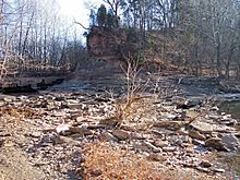
This picture from 2006 shows what's left of the old channel dug across the Jug peninsula. The low water bridge, which helps control the creek's flow, is on the left.
-
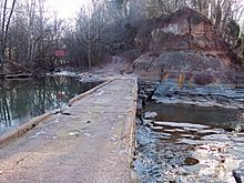
This photo shows the low water bridge built in 1947. It helps keep Middle Island Creek flowing around the Jug, which is just to the right of the picture.


