
Middle Island Creek facts for kids
Quick facts for kids Middle Island Creek |
|
|---|---|

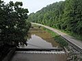
View downstream from the North Bend Rail Trail in West Union
|
|

A map of Middle Island Creek and its watershed
|
|
| Country | United States |
| State | West Virginia |
| Physical characteristics | |
| Main source | Confluence of Meathouse Fork and Buckeye Creek Smithburg, Doddridge County 794 ft (242 m) 39°17′04″N 80°43′41″W / 39.28444°N 80.72806°W |
| River mouth | Ohio River St. Marys 607 ft (185 m) 39°24′09″N 81°12′08″W / 39.40250°N 81.20222°W |
| Length | 77 mi (124 km) |
| Basin features | |
| Basin size | 565 sq mi (1,460 km2) |
| Tributaries | |
Middle Island Creek is a long river in northwestern West Virginia, United States. It stretches for about 77 miles (124 km). This creek is a tributary of the larger Ohio River. It helps drain an area of 565 square miles (1,463 km²) on the Allegheny Plateau.
Early travelers on the Ohio River in the late 1700s gave the creek its name. They noticed that the creek's mouth was directly across from Middle Island in the Ohio River. Fun fact: Middle Island Creek is the longest stream in West Virginia that is called a "creek"!
Contents
Exploring Middle Island Creek's Path
Where Does Middle Island Creek Start?
Middle Island Creek begins in Doddridge County at a place called Smithburg. It forms when two smaller streams, Meathouse Fork and Buckeye Creek, join together. This joining point is called a confluence.
Middle Island Creek's Journey to the Ohio River
From Smithburg, the creek flows mostly northwest. It winds its way through Doddridge and Tyler Counties. Along its path, it passes through small communities like Avondale and towns such as West Union.
In Tyler County, it goes through places like Josephs Mills and Middlebourne. After Middlebourne, the creek turns southwest. It then flows almost parallel to the Ohio River, even with its many bends.
It continues through communities like Shiloh and Falls Mills. Finally, it enters Pleasants County. Here, it flows past Arvilla and Sugar Valley. Middle Island Creek then joins the Ohio River in the city of St. Marys.
The last 12 square miles (31 km²) of the creek are often covered by water. This happens because of the Willow Island Locks and Dam downstream on the Ohio River.
Smaller Streams Joining the Creek
Many smaller streams flow into Middle Island Creek. These are called tributaries. Some of the biggest ones include:
- Arnold Creek (joins near the Doddridge and Tyler county line)
- McElroy Creek
- Indian Creek
- Point Pleasant Creek
- Sancho Creek (all these join in Tyler County)
- Sugar Creek
- McKim Creek (both join in Pleasants County)
The Jug: A Unique Bend in the Creek
One of the most interesting parts of Middle Island Creek is a huge bend called "the Jug." It's located upstream from Middlebourne. The creek makes a 7-mile (11 km) loop, but then comes back to within just 100 feet (30 m) of itself!
Long ago, before 1800, a settler named George Gregg dug a channel across this narrow point. This channel, called a mill race, used the water's power to run a gristmill (for grinding grain) and a sawmill. Floods destroyed these mills in 1852, and later mills also washed away.
In 1947, a special bridge was built that partly blocked the cut-through. This helped the water flow steadily around the big bend again. The land inside this creek loop is now a Wildlife Management Area. It is managed by the state of West Virginia.
What Was Middle Island Creek Called Before?
The Geographic Names Information System has collected some old names for Middle Island Creek. Historically, it was also known as:
- Be-Van-Soss Creek of the Indians
- Be-van-Soss Creek of the Indians
- Be-van-soss
- Be-yan-soss
- Bulls Creek
- By-En-Soss Creek
- By-en-Soss Creek
- By-en-soss
- Louisa River
Economy: How the Creek Area Was Used
In the late 1800s and 1900s, the area around Middle Island Creek was very important for getting oil and gas. An oil boom (a time of quick growth in oil production) started in the 1860s.
This boom was biggest in Middlebourne in the 1890s. An oil refinery (a factory that processes oil) operated in St. Marys from 1914 to 1987. Because there was so much natural gas, factories for making glass and carbon were built in West Union and Smithburg in the early 1900s.
Fish Life: Fishing in Middle Island Creek
Middle Island Creek is a slow-moving stream with a gentle slope. It is known as one of the best places in West Virginia for muskellunge fishing. For many years, the West Virginia Division of Natural Resources collected muskie eggs from the creek. These eggs were used to stock fish in other streams across the state.
Other fish you can commonly find in Middle Island Creek include:
- spotted bass
- smallmouth bass
- rock bass
- Different types of sunfish
- freshwater drum
- channel catfish
- flathead catfish
Images for kids
-

Middle Island Creek as it approaches the Jug in Tyler County
-
Middle Island Creek as viewed upstream from the North Bend Rail Trail in West Union


