Indian Creek (Middle Island Creek tributary) facts for kids
Quick facts for kids Indian Creek |
|
|---|---|

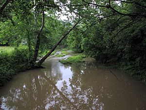
Indian Creek in Big Moses
|
|

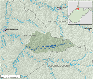
A map of Indian Creek and its watershed
|
|
| Country | United States |
| State | West Virginia |
| County | Tyler |
| Physical characteristics | |
| Main source | near Dale 1,058 ft (322 m) 39°26′54″N 80°37′36″W / 39.4484168°N 80.6267645°W |
| River mouth | Middle Island Creek south of Blue 686 ft (209 m) 39°26′39″N 80°49′24″W / 39.4442467°N 80.8234385°W |
| Length | 14.8 mi (23.8 km) |
| Basin features | |
| Basin size | 32.3 sq mi (84 km2) |
| Hydrologic Unit Code | 050302010501 (USGS) |
Indian Creek is a small river, or a "tributary," in northern West Virginia, United States. It's about 14.8 miles (23.8 kilometers) long. A tributary is like a smaller stream that flows into a bigger river. Indian Creek flows into Middle Island Creek, which then joins the Ohio River. The Ohio River eventually flows into the mighty Mississippi River! This means Indian Creek is part of the huge Mississippi River "watershed." A watershed is all the land where water drains into one main river.
About Indian Creek
Indian Creek helps drain an area of about 32.3 square miles (83.7 square kilometers). This area is a rural part of the Allegheny Plateau. The Allegheny Plateau is a high, mostly flat area of land. This part of the plateau is also "unglaciated," which means it was never covered by huge sheets of ice called glaciers during the Ice Ages.
Where Does It Flow?
Indian Creek flows entirely within Tyler County in West Virginia. It starts near where Tyler, Wetzel, and Doddridge counties meet.
The creek generally flows towards the west. Along its journey, it passes through several small communities. These include Dale, Stringtown, Braden, Booher, and Big Moses. Finally, Indian Creek flows into Middle Island Creek from the east, just a short distance south of the community of Blue.
 | DeHart Hubbard |
 | Wilma Rudolph |
 | Jesse Owens |
 | Jackie Joyner-Kersee |
 | Major Taylor |

