Sancho Creek facts for kids
Quick facts for kids Sancho Creek |
|
|---|---|

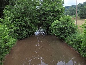
Sancho Creek east of Locke
|
|

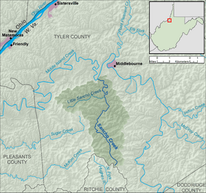
A map of Sancho Creek and its watershed
|
|
| Country | United States |
| State | West Virginia |
| County | Tyler |
| Physical characteristics | |
| Main source | south of Bearsville 1,033 ft (315 m) 39°22′30″N 80°54′05″W / 39.375°N 80.9013889°W |
| River mouth | Middle Island Creek southwest of Middlebourne 656 ft (200 m) 39°28′36″N 80°55′47″W / 39.4767442°N 80.9298299°W |
| Length | 9.6 mi (15.4 km) |
| Basin features | |
| Basin size | 22.2 sq mi (57 km2) |
| Hydrologic Unit Code | 050302010505 (USGS) |
Sancho Creek is a small waterway, or tributary, located in northwestern West Virginia in the United States. It flows into Middle Island Creek, which then joins the Ohio River. From there, the water eventually reaches the mighty Mississippi River.
This creek is about 9.6 miles (15.4 km) long. It helps drain an area of about 22.2 square miles (57.5 km2). This area is part of a larger drainage basin, which is like a giant funnel that collects all the rain and snowmelt.
Contents
Exploring Sancho Creek's Path
Sancho Creek and its entire watershed (the land area that drains into it) are found completely within Tyler County.
Where Does the Creek Start?
The creek begins in the southern part of Tyler County. This is close to where Tyler County meets Ritchie County. The starting point is south of a small community called Bearsville.
Where Does the Creek Flow?
From its start, Sancho Creek generally flows north. It passes through the quiet community of Bearsville. Finally, it meets Middle Island Creek. This meeting point is about 1.8 miles (2.9 km) southwest of Middlebourne.
Did You Know?
According to the Geographic Names Information System, Sancho Creek has also been known by another spelling in the past. Sometimes, people called it "Sanco Creek."
 | Precious Adams |
 | Lauren Anderson |
 | Janet Collins |

